IMAGES TAKEN NEAR TO
Carlisle Road, CARLISLE, CA5 7JS
Introduction
This page details the photographs taken nearby to Carlisle Road, CA5 7JS by members of the Geograph project.
The Geograph project started in 2005 with the aim of publishing, organising and preserving representative images for every square kilometre of Great Britain, Ireland and the Isle of Man.

There are currently over 7.5m images from over14,400 individuals and you can help contribute to the project by visiting https://www.geograph.org.uk
Image Map
Images are licensed for reuse under creativecommons.org/licenses/by-sa/2.0
Notes
- Clicking on the map will re-center to the selected point.
- The higher the marker number, the further away the image location is from the centre of the postcode.
Image Listing (19 Images Found)
Images are licensed for reuse under creativecommons.org/licenses/by-sa/2.0
Image
Details
Distance
1
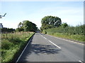
B5299 near Caldewhurst
Heading south west towards Dalston.
Image: © JThomas
Taken: 17 Sep 2016
0.04 miles
2
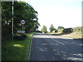
Entering Dalston
Heading south west on the B5299.
Image: © JThomas
Taken: 17 Sep 2016
0.06 miles
3

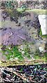
Western parapet of bridge taking B5299 (Carlisle Road) over watercourse
There is an Ordnance Survey benchmark Image on top of the parapet about 18" from its near end
Image: © Roger Templeman
Taken: 30 Dec 2021
0.13 miles
4
Benchmark on bridge parapet on west side of B5299 north of Dalston
Ordnance Survey rivet benchmark levelled at 41.437m above Newlyn Datum verified 1972
Image: © Roger Templeman
Taken: 30 Dec 2021
0.15 miles
5
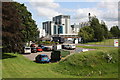
Nescafe factory viewed from Carlisle Road
Image: © Roger Templeman
Taken: 8 Aug 2019
0.16 miles
6
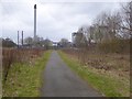
Nestl? works, Dalston
For details see Image In the foreground, the Caldew Cycleway, a fine tarmac path which runs alongside the River Caldew for some 9 km from Carlisle. It forms part of both National Cycle Route 7 (Inverness to Sunderland) and Route 10 (Cockermouth to North Shields), neither of which are in the least bit direct!
Image: © Oliver Dixon
Taken: 25 Jan 2016
0.17 miles
7
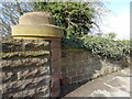
Rounded pilaster
Rounded pilasters with substantial sandstone caps at the end of the parapet walls are a feature of the original bridges over the Maryport and Carlisle section of the Cumbria Coast Line.
There is an Ordnance Survey cut benchmark on the face of the wall to the right of the pilaster (photograph Image).
Image: © Adrian Taylor
Taken: 25 Feb 2021
0.18 miles
8
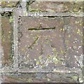
Benchmark, Carlisle Road Railway Bridge
Detail of the Ordnance Survey cut benchmark on the sandstone wall adjacent to the parapet of the railway bridge on Carlisle Road, Dalston. The benchmark marks a height of 44.7269m above sea level (Ordnance Datum Newlyn) last verified in 1972 (location photograph Image).
Image: © Adrian Taylor
Taken: 25 Feb 2021
0.18 miles
9

Nestl? Dalston factory gate
The Nestlé factory employs over three hundred people in Dalston, using on average 63 million litres of milk annually to produce a range of Nescafé products, Latte and Coffee Mate, the latter being a whitener for beverages.
Image: © Adrian Taylor
Taken: 21 Feb 2021
0.18 miles
10
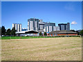
Nestl? Factory, Dalston
The factory produces milk-based beverages including cappuccino, hot chocolate and Coffee-Mate.
The low brick building to the right is Dalston Masonic Hall.
Image: © Rose and Trev Clough
Taken: 16 Sep 2015
0.19 miles