IMAGES TAKEN NEAR TO
Gaitsgill, Dalston, CARLISLE, CA5 7AH
Introduction
This page details the photographs taken nearby to CA5 7AH by members of the Geograph project.
The Geograph project started in 2005 with the aim of publishing, organising and preserving representative images for every square kilometre of Great Britain, Ireland and the Isle of Man.

There are currently over 7.5m images from over14,400 individuals and you can help contribute to the project by visiting https://www.geograph.org.uk
Image Map
Images are licensed for reuse under creativecommons.org/licenses/by-sa/2.0
Notes
- Clicking on the map will re-center to the selected point.
- The higher the marker number, the further away the image location is from the centre of the postcode.
Image Listing (15 Images Found)
Images are licensed for reuse under creativecommons.org/licenses/by-sa/2.0
Image
Details
Distance
1
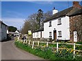
Royal Oak House, Gaitsgill
The two storey white house used to be a pub called the Royal Oak. Don't know when it closed, but seems to have been still a pub in 1984, when it and the adjoining cottage (rt) were given listed building status http://www.britishlistedbuildings.co.uk/en-78316-royal-oak-and-adjoining-house-dalston-cum#.WFhmp33Dsrg .
The Pen Beck runs between the houses and the road.
Image: © Rose and Trev Clough
Taken: 21 Apr 2016
0.01 miles
2
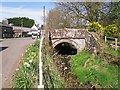
Penbeck Bridge, Gaitsgill
The Pen Beck runs alongside the main street through the hamlet of Gaitsgill.
Image: © Rose and Trev Clough
Taken: 21 Apr 2016
0.01 miles
3
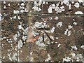
Ordnance Survey Cut Mark
The mark can be found on Gaitsgill Bridge.
This benchmark has a recorded height of 69.232 metres above sea level.
For more detail see : https://www.bench-marks.org.uk/bm138388
Image: © Peter Wood
Taken: 1 Aug 2020
0.02 miles
4
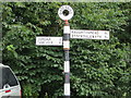
Is it Gatesgill or Gaitsgill?
To Cumberland County Council it is the former whilst to the Ordnance Survey it is the latter.
Image: © Peter Wood
Taken: 1 Aug 2020
0.02 miles
5
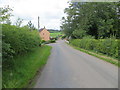
Minor road at Gaitsgill
Looking westward.
Image: © Peter Wood
Taken: 1 Aug 2020
0.02 miles
6
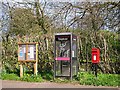
Roadside amenities at Gaitsgill
Dalston Parish Council noticeboard, telephone box and post box.
There was a notice from BT in the phone box saying that it was not being used sufficiently to continue pay phone service at this location. A request had been made by the Community Heartbeat Trust to adopt the kiosk and install a heart defibrillator.
Image: © Rose and Trev Clough
Taken: 21 Apr 2016
0.03 miles
7

Primrose Hall, Gaitsgill
Village hall, built in 1885 by Lt Col Carleton Salkeld of Holm(e) Hill for workers on his estate. The hall is named after the Primrose League, an organisation for Conservative Party supporters founded two years previously https://en.wikipedia.org/wiki/Primrose_League (information from 'The Cumbria Village Book' reproduced here http://www.visitoruk.com/Carlisle/gaitsgill-C592-V27124.html ).
There is a plaque above the door - see Image .
Primrose hall, together with two adjoining cottages, is a listed building http://www.imagesofengland.org.uk/details/default.aspx?id=78315 .
Image: © Rose and Trev Clough
Taken: 21 Apr 2016
0.04 miles
8
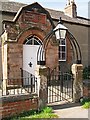
Entrance to the Primrose Hall
Image: © Rose and Trev Clough
Taken: 21 Apr 2016
0.04 miles
9
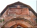
Dated inscription, Primrose Hall
Above the door to Image .
It says 'LIEUT. COL. CARLETON SALKELD BUILT THIS HALL A.D.1885'.
There is a shield with a diagonal lattice ('fretty' in heraldic terms). Other examples of Salkeld coats of arms in Cumbria are shown here http://www.geog.port.ac.uk/webmap/thelakes/html/topics/arms0087.htm .
Colonel Salkeld was a local landowner who lived at Holme Hill (or Holm Hill), a mansion now occupied by Lime House School http://www.geograph.org.uk/photo/279353 .
For more information about the hamlet of Gaitsgill see extract from 'The Cumbria Village Book', written 1991 http://www.visitoruk.com/Carlisle/gaitsgill-C592-V27124.html .
Image: © Rose and Trev Clough
Taken: 21 Apr 2016
0.04 miles
10
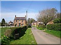
Houses in Gaitsgill
Entering the hamlet from the south.
Image: © Rose and Trev Clough
Taken: 21 Apr 2016
0.05 miles