IMAGES TAKEN NEAR TO
Wampool Close, CARLISLE, CA5 6BF
Introduction
This page details the photographs taken nearby to Wampool Close, CA5 6BF by members of the Geograph project.
The Geograph project started in 2005 with the aim of publishing, organising and preserving representative images for every square kilometre of Great Britain, Ireland and the Isle of Man.

There are currently over 7.5m images from over14,400 individuals and you can help contribute to the project by visiting https://www.geograph.org.uk
Image Map
Images are licensed for reuse under creativecommons.org/licenses/by-sa/2.0
Notes
- Clicking on the map will re-center to the selected point.
- The higher the marker number, the further away the image location is from the centre of the postcode.
Image Listing (57 Images Found)
Images are licensed for reuse under creativecommons.org/licenses/by-sa/2.0
Image
Details
Distance
2
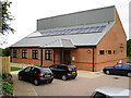
Thursby Parish Hall
Quite a change from a similarly titled photo taken in 2006 Image . The new hall was opened in 2010, it is set further back from the road than the old one, which has been demolished.
More information on the hall's website http://thursbyparishhall.weebly.com .
Image: © Rose and Trev Clough
Taken: 21 Sep 2013
0.11 miles
3
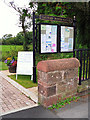
Thursby parish noticeboard
In the grounds of the parish hall, in Matty Lonning.
Image: © Rose and Trev Clough
Taken: 21 Sep 2013
0.13 miles
4
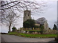
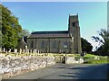
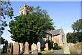
Parish Church Thursby
Its location on a small hill dominates the village
Image: © Bob Jenkins
Taken: 13 Jan 2006
0.13 miles
5
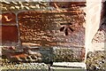
Benchmark on wall at farm entrance
Ordnance Survey cut mark benchmark levelled at 37.746m above Newlyn Datum, verified in 1970
Image: © Luke Shaw
Taken: 13 Aug 2019
0.15 miles
6
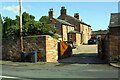
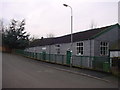
Entrance to farm from SE side of road in SW Thursby
There is an Ordnance Survey benchmark Image on the roadside wall on the left hand side of the entrance, right of wheelie bins
Image: © Luke Shaw
Taken: 13 Aug 2019
0.16 miles
7
St Andrew's Church
Ordnance Survey documents indicate that a benchmark was levelled at 124.413 feet above Liverpool Datum on a church at this location during the 1843/4 Kirkby Kendal to Carlisle Survey. The surveyor's description was 'Branch Levelling. No. 361. Thursby Church. Bolt in plinth of pillar at West side'. However, the present church was built in 1846.
Image: © Roger Templeman
Taken: 13 Aug 2019
0.16 miles
8
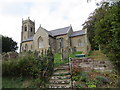
The Church of St Andrew at Thursby
Viewed from the south.
Image: © Peter Wood
Taken: 19 Sep 2014
0.17 miles