IMAGES TAKEN NEAR TO
Armathwaite, CARLISLE, CA4 9TS
Introduction
This page details the photographs taken nearby to CA4 9TS by members of the Geograph project.
The Geograph project started in 2005 with the aim of publishing, organising and preserving representative images for every square kilometre of Great Britain, Ireland and the Isle of Man.

There are currently over 7.5m images from over14,400 individuals and you can help contribute to the project by visiting https://www.geograph.org.uk
Image Map (Loading...)


Getting Data...Please wait
Leaflet Map data © OpenStreetMap
Images are licensed for reuse under creativecommons.org/licenses/by-sa/2.0
Notes
- Clicking on the map will re-center to the selected point.
- The higher the marker number, the further away the image location is from the centre of the postcode.
Image Listing (7 Images Found)
Images are licensed for reuse under creativecommons.org/licenses/by-sa/2.0
Image
Details
Distance
1
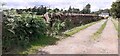
Entrance track to Castlerigg Cottage from north side of road
There is a field gateway with stone gateposts on the left hand side of the track
Image: © Roger Templeman
Taken: 2 Aug 2022
0.01 miles
2
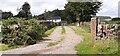
Entrance gateway to Castlerigg Cottage from north side of road
Image: © Luke Shaw
Taken: 2 Aug 2022
0.01 miles
3
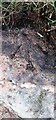
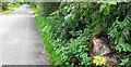
Benchmark on rock on south side of road at Bleaberry Hill
Ordnance Survey pivot benchmark levelled at 152.653m above Newlyn Datum verified 1973
Image: © Roger Templeman
Taken: 2 Aug 2022
0.14 miles
4
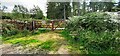
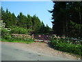
Gateway into Lazonby Fell Plantation at Bleaberry Hill (Brackenburgh Estate)
Ordnance Survey records indicate that a benchmark levelled at 152.653m above Newlyn Datum was verified in 1974 on a stone in the wall on the left hand side of the gateway
Image: © Roger Templeman
Taken: 2 Aug 2022
0.17 miles
5
Track Junction
Farm track junction with the Lazonby to A6 road
Image: © Alexander P Kapp
Taken: 9 Jun 2006
0.18 miles
6
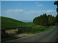
Rural road heading east past Bleaberry Hill
There is an Ordnance Survey benchmark Image on top of the rock on the verge in the right foreground
Image: © Roger Templeman
Taken: 2 Aug 2022
0.20 miles
7
Gateway
Access point to woodland on The Brackenburgh Estate
Image: © Alexander P Kapp
Taken: 9 Jun 2006
0.22 miles