IMAGES TAKEN NEAR TO
Ainstable, CARLISLE, CA4 9RG
Introduction
This page details the photographs taken nearby to CA4 9RG by members of the Geograph project.
The Geograph project started in 2005 with the aim of publishing, organising and preserving representative images for every square kilometre of Great Britain, Ireland and the Isle of Man.

There are currently over 7.5m images from over14,400 individuals and you can help contribute to the project by visiting https://www.geograph.org.uk
Image Map
Images are licensed for reuse under creativecommons.org/licenses/by-sa/2.0
Notes
- Clicking on the map will re-center to the selected point.
- The higher the marker number, the further away the image location is from the centre of the postcode.
Image Listing (3 Images Found)
Images are licensed for reuse under creativecommons.org/licenses/by-sa/2.0
Image
Details
Distance
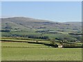
2
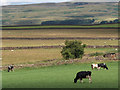
Slack
The cows are in the field between Bramery and Slack. The sheep graze the rougher pastures in the fields north of the Slack/Far Shields access lane.
Image: © Andrew Smith
Taken: 27 Jul 2006
0.17 miles
3
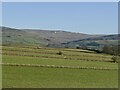
Drystone walls near Slack
A series of parallel walls against a Pennine backdrop.
Image: © Richard Webb
Taken: 2 Dec 2021
0.23 miles