IMAGES TAKEN NEAR TO
Ainstable, CARLISLE, CA4 9QN
Introduction
This page details the photographs taken nearby to CA4 9QN by members of the Geograph project.
The Geograph project started in 2005 with the aim of publishing, organising and preserving representative images for every square kilometre of Great Britain, Ireland and the Isle of Man.

There are currently over 7.5m images from over14,400 individuals and you can help contribute to the project by visiting https://www.geograph.org.uk
Image Map
Images are licensed for reuse under creativecommons.org/licenses/by-sa/2.0
Notes
- Clicking on the map will re-center to the selected point.
- The higher the marker number, the further away the image location is from the centre of the postcode.
Image Listing (20 Images Found)
Images are licensed for reuse under creativecommons.org/licenses/by-sa/2.0
Image
Details
Distance

2

Church of St Michael & All Angels, Ainstable - May 2017 (3)
Village War Memorial, situated in the lych gate.
For information on the Church, see: Image] .
Image: © The Carlisle Kid
Taken: 25 May 2017
0.14 miles
3
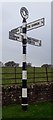
Old Direction Sign - Signpost by Ainstable crossroads
Annulus finial - 4 arms; Cumberland named halo by the UC road, in parish of Ainstable (Eden District), crossroads in Ainstable village.
To be surveyed
Milestone Society National ID: CU_NY5346
Image: © Milestone Society
Taken: Unknown
0.15 miles
4

18th century table-stone at St Michael?s
The inscription on this very old stone reads:
Here lyeth the Body
of Peter Hodgson
of Bascodike foot
who dyed July ye
31 1700
Image: © Mary and Angus Hogg
Taken: 18 May 2022
0.15 miles
5

Church of St Michael & All Angels, Ainstable - May 2017 (6)
The Vicarage.
For information on the Church, see: Image] .
Image: © The Carlisle Kid
Taken: 25 May 2017
0.15 miles
6

A winged soul at St Michael?s
A closer look at this interesting old stone. The carving represents the departed’s soul rising up to Heaven. Unfortunately, the sunken stone was too weathered to make out any other information.
Image: © Mary and Angus Hogg
Taken: 18 May 2022
0.15 miles
7

In St Michael?s graveyard
This view looks towards the lych gate at the entrance. The sunken stone in the foreground carries the carving of a winged soul.
Image: © Mary and Angus Hogg
Taken: 18 May 2022
0.15 miles
8

Church of St Michael & All Angels, Ainstable - May 2017 (1)
Built on an imposing site overlooking the village of Ainstable, the current Church of St Michael & All Angels dates from 1872. It replaced a late 18th Century Church, which itself was built on a site of worship dating back to Norman times.
The Church is open daily (closed from 16.00), a Guide Book is available and donations are welcome. There are many imposing internal features including Victorian stained glass and an 1888 installed rood screen. This will be covered in a future visit.
More information on the Church can be found on the Diocese of Carlisle web site at: http://www.carlislediocese.org.uk/church/ainstable-st-michael-all-angels.html
The Church is Grade II listed.
Image: © The Carlisle Kid
Taken: 25 May 2017
0.15 miles
9

Church of St Michael & All Angels, Ainstable - May 2017 (2)
View of the south face and lych gate from the village.
For information on this Church, see: Image] .
Image: © The Carlisle Kid
Taken: 25 May 2017
0.15 miles
10
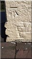
Benchmark on 'Roads End'
Ordnance Survey cut mark benchmark levelled at 124.861m above Newlyn Datum verified in 1972
Image: © Luke Shaw
Taken: 17 Apr 2021
0.16 miles