
IMAGES TAKEN NEAR TO
Ainstable, CARLISLE, CA4 9QA
Introduction
This page details the photographs taken nearby to CA4 9QA by members of the Geograph project.
The Geograph project started in 2005 with the aim of publishing, organising and preserving representative images for every square kilometre of Great Britain, Ireland and the Isle of Man.

There are currently over 7.5m images from over14,400 individuals and you can help contribute to the project by visiting https://www.geograph.org.uk
Image Map
Images are licensed for reuse under creativecommons.org/licenses/by-sa/2.0
Notes
- Clicking on the map will re-center to the selected point.
- The higher the marker number, the further away the image location is from the centre of the postcode.
Image Listing (17 Images Found)
Images are licensed for reuse under creativecommons.org/licenses/by-sa/2.0
Image
Details
Distance
1
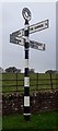
Old Direction Sign - Signpost by Ainstable crossroads
Annulus finial - 4 arms; Cumberland named halo by the UC road, in parish of Ainstable (Eden District), crossroads in Ainstable village.
To be surveyed
Milestone Society National ID: CU_NY5346
Image: © Milestone Society
Taken: Unknown
0.08 miles
2
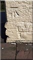
Benchmark on 'Roads End'
Ordnance Survey cut mark benchmark levelled at 124.861m above Newlyn Datum verified in 1972
Image: © Luke Shaw
Taken: 17 Apr 2021
0.09 miles
3
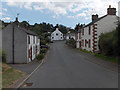
Ainstable
Looking up to the New Crown Inn.
Image: © Andrew Smith
Taken: 27 Jul 2006
0.10 miles
4
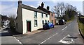
Road Ends at cross roads in Ainstable
There is an Ordnance Survey benchmark Image on the near corner, right hand face, of the white-painted house.
Image: © Luke Shaw
Taken: 17 Apr 2021
0.10 miles
5
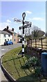
View towards 'Road Ends' at crossroads in Ainstable
Image: © Roger Templeman
Taken: 17 Apr 2021
0.11 miles
6
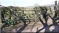
View of farmland through gate on north side of track west of Fearnlands
The track goes left to Aimbank
Image: © Luke Shaw
Taken: 17 Apr 2021
0.20 miles
7
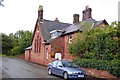
The Old School, Ainstable
This former school now functions as a library.
Image: © Trevor Harris
Taken: 6 Sep 2008
0.22 miles
8

Benchmark on building at road junction west of Ainstable
Ordnance Survey cut mark benchmark with extended datum cut levelled at 112.513m verified in 1972
Image: © Roger Templeman
Taken: 17 Apr 2021
0.23 miles
9

Buildings at south side of T-junction west of Ainstable
There is an Ordnance Survey benchmark Image on the near corner of the roadside building below a downpipe
Image: © Roger Templeman
Taken: 17 Apr 2021
0.23 miles
10

Farmland, Ainstable
Looking up to Ainstable church from the Methodist church at Rowfoot.
Image: © Andrew Smith
Taken: 27 Jul 2006
0.24 miles