IMAGES TAKEN NEAR TO
Ainstable, CARLISLE, CA4 9PZ
Introduction
This page details the photographs taken nearby to CA4 9PZ by members of the Geograph project.
The Geograph project started in 2005 with the aim of publishing, organising and preserving representative images for every square kilometre of Great Britain, Ireland and the Isle of Man.

There are currently over 7.5m images from over14,400 individuals and you can help contribute to the project by visiting https://www.geograph.org.uk
Image Map
Images are licensed for reuse under creativecommons.org/licenses/by-sa/2.0
Notes
- Clicking on the map will re-center to the selected point.
- The higher the marker number, the further away the image location is from the centre of the postcode.
Image Listing (18 Images Found)
Images are licensed for reuse under creativecommons.org/licenses/by-sa/2.0
Image
Details
Distance
1

Benchmark on building at road junction west of Ainstable
Ordnance Survey cut mark benchmark with extended datum cut levelled at 112.513m verified in 1972
Image: © Roger Templeman
Taken: 17 Apr 2021
0.02 miles
2

Buildings at south side of T-junction west of Ainstable
There is an Ordnance Survey benchmark Image on the near corner of the roadside building below a downpipe
Image: © Roger Templeman
Taken: 17 Apr 2021
0.02 miles
3

Farmland, Ainstable
Looking up to Ainstable church from the Methodist church at Rowfoot.
Image: © Andrew Smith
Taken: 27 Jul 2006
0.02 miles
4

Old Direction Sign - Signpost in Ainstable parish
Annulus finial - 3 arms; Cumberland named halo by the UC road, in parish of Ainstable (Eden District), T-junction West of Ainstable village.
To be surveyed
Milestone Society National ID: CU_NY5246
Image: © Milestone Society
Taken: Unknown
0.03 miles
5

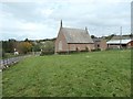
Ainstable Methodist Church
Located on the western edge of the village at Rowfoot.
Image: © Mary and Angus Hogg
Taken: 18 May 2022
0.03 miles
6

Cumberland County Council signpost at Rowfoot
Outside Ainstable Methodist Church, with the Anglican village church on the hillside beyond.
Image: © Christine Johnstone
Taken: 22 Oct 2019
0.03 miles
7
Ainstable Methodist Church, at Rowfoot
Well, that its modern name, according to the noticeboard by the door. The date stone says 'Wesleyan Chapel 1861'.
Image: © Christine Johnstone
Taken: 22 Oct 2019
0.03 miles
8

Road junction at Ainstable
The notice gives information about local events that celebrate the Queen’s Platinum Jubilee.
Image: © Mary and Angus Hogg
Taken: 18 May 2022
0.03 miles
9
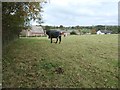
Public footpath crossing a paddock at Rowfoot
Heading north, along the field edge.
Image: © Christine Johnstone
Taken: 22 Oct 2019
0.06 miles
