IMAGES TAKEN NEAR TO
Mill Brow, CARLISLE, CA4 9PJ
Introduction
This page details the photographs taken nearby to Mill Brow, CA4 9PJ by members of the Geograph project.
The Geograph project started in 2005 with the aim of publishing, organising and preserving representative images for every square kilometre of Great Britain, Ireland and the Isle of Man.

There are currently over 7.5m images from over14,400 individuals and you can help contribute to the project by visiting https://www.geograph.org.uk
Image Map
Images are licensed for reuse under creativecommons.org/licenses/by-sa/2.0
Notes
- Clicking on the map will re-center to the selected point.
- The higher the marker number, the further away the image location is from the centre of the postcode.
Image Listing (48 Images Found)
Images are licensed for reuse under creativecommons.org/licenses/by-sa/2.0
Image
Details
Distance
1
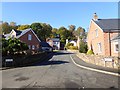
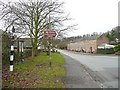
Mill Brow, Armathwaite
Modern housing estate in the southern part of the village.
Image: © Oliver Dixon
Taken: 25 Oct 2016
0.03 miles
2
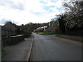
Armathwaite village
A minor road leading to High Hesket, on the A6.
Image: © David Purchase
Taken: 28 Apr 2018
0.05 miles
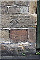
3
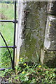
Benchmark on gatepost south of village
Ordnance Survey cut mark benchmark described on the Bench Mark Database at http://www.bench-marks.org.uk/bm43678
Image: © Roger Templeman
Taken: 16 Jun 2012
0.09 miles
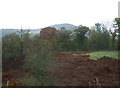
4
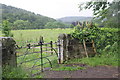
Gateway and footpath stile south of the village
There is an OS benchmark Image on the gatepost at the right hand side of the gateway
Image: © Roger Templeman
Taken: 16 Jun 2012
0.09 miles
5
Houses, Armathwaite
This row of double-fronted houses is on the 1868 six-inch map. For a close-up of the guide post see Image
Image: © Humphrey Bolton
Taken: 27 Jan 2009
0.11 miles
6
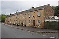
Converted farm buildings on Front Street
There is an OS benchmark Image on the front corner of the nearest house
Image: © Roger Templeman
Taken: 16 Jun 2012
0.14 miles
8
Benchmark on #5 The Barn, Front Street
Ordnance Survey cut mark benchmark described on the Bench Mark Database at http://www.bench-marks.org.uk/bm43420
Image: © Roger Templeman
Taken: 16 Jun 2012
0.15 miles
9
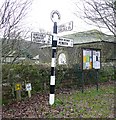
Guide Post, Armathwaite
Many of these old guide posts are neglected and rusty, but this one has a fresh coat of paint. Notice how the lettering 'Cumberland County Council' down the post is white in the black stripes and black in the white stripes.
Image: © Humphrey Bolton
Taken: 27 Jan 2009
0.15 miles
10
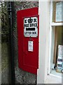
Letter box next to the post office, Armathwaite
This looks quite old, so I think E R must be Edward VII.
Image: © Humphrey Bolton
Taken: 27 Jan 2009
0.15 miles