IMAGES TAKEN NEAR TO
The Orchard, CARLISLE, CA4 8LS
Introduction
This page details the photographs taken nearby to The Orchard, CA4 8LS by members of the Geograph project.
The Geograph project started in 2005 with the aim of publishing, organising and preserving representative images for every square kilometre of Great Britain, Ireland and the Isle of Man.

There are currently over 7.5m images from over14,400 individuals and you can help contribute to the project by visiting https://www.geograph.org.uk
Image Map
Images are licensed for reuse under creativecommons.org/licenses/by-sa/2.0
Notes
- Clicking on the map will re-center to the selected point.
- The higher the marker number, the further away the image location is from the centre of the postcode.
Image Listing (46 Images Found)
Images are licensed for reuse under creativecommons.org/licenses/by-sa/2.0
Image
Details
Distance
1
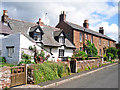
Houses, Great Corby
The whitewashed cottage dates from the late 17th or early 18th century, the pair of red sandstone houses from the 1830s-40s (see Images of England http://www.imagesofengland.org.uk/details/default.aspx?id=77717 and http://www.imagesofengland.org.uk/details/default.aspx?id=77718 ).
Image: © Rose and Trev Clough
Taken: 28 Jun 2015
0.05 miles
2

Old Direction Sign - Signpost in Great Corby, Hayton Parish
Annulus finial - 3 arms; Cumberland named halo by the UC road, in parish of Hayton (Carlisle District), Great Corby, by the Queen Inn.
Surveyed
Milestone Society National ID: CU_NY4754A
Image: © Milestone Society
Taken: Unknown
0.07 miles
4
The Old Forge
The building has seen use as a forge, a garage, an office and now by Cumberland Breweries Ltd. There is an Ordnance Survey benchmark Image on the buttress on the right hand side of the building where it joins a wall.
Image: © Roger Templeman
Taken: 31 Aug 2021
0.07 miles
5

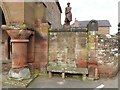
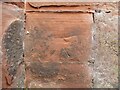
Weathered benchmark on old building at NW quadrant of crossroads
Ordnance Survey cut mark benchmark described on the Bench Mark Database at www.bench-marks.org.uk/bm140399
Image: © Roger Templeman
Taken: 31 Aug 2021
0.07 miles
6
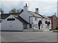
Vulcan by the forge
Vulcan, the Roman god of fire and of the forge stands beside the blacksmith’s shop in Great Corby. The blacksmith’s shop, built in 1833 and designed to represent Vulcan’s Forge is now the Great Corby Brewhouse producing craft beers.
There is an indistinct, very weathered Ordnance Survey cut benchmark on the wall between the short, stout column of the Brewhouse and the stone seat (photograph Image).
Image: © Adrian Taylor
Taken: 7 Mar 2021
0.07 miles
7
Benchmark, Great Corby Brewhouse
Detail of a weathered Ordnance Survey cut benchmark on the front of the Great Corby Brewhouse, formerly the village forge. The benchmark marks a height of 56.5008m above sea level (Ordnance Datum Newlyn) last verified in 1972 (location photograph Image).
Image: © Adrian Taylor
Taken: 7 Mar 2021
0.07 miles
8
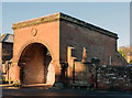
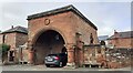
Entrance to Cumberland Breweries, Great Corby
Probably once part of the Corby Castle estate, this is now the entrance to the Cumberland Breweries.
Photograph is for record only - I have no connection with this business and cannot advise on its products or services.
Image: © The Carlisle Kid
Taken: 24 Nov 2016
0.07 miles
9

Frozen to the spot!
Overnight frost is still on a statue at the entrance to the Cumberland Breweries, Great Corby.
Image: © The Carlisle Kid
Taken: 24 Nov 2016
0.07 miles
10
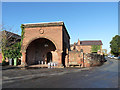
Great Corby village
This imposing structure in the centre of Great Corby is a former blacksmith's shop, built in 1833 for the Howard family of Corby Castle, in imitation of Vulcan's forge. It is a Grade II listed building - more information at http://list.historicengland.org.uk/resultsingle.aspx?uid=1335516. It appears now to serve as the beer cellar for the Queen's Inn on the opposite side of the village green. (information supplied by Dave Dunford)
Image: © Oliver Dixon
Taken: 5 Nov 2014
0.07 miles