IMAGES TAKEN NEAR TO
Wetheral, CARLISLE, CA4 8HD

Introduction

This page details the photographs taken nearby to CA4 8HD by members of the Geograph project.

The Geograph project started in 2005 with the aim of publishing, organising and preserving representative images for every square kilometre of Great Britain, Ireland and the Isle of Man.

There are currently over 7.5m images from over14,400 individuals and you can help contribute to the project by visiting https://www.geograph.org.uk

Image Map


Images are licensed for reuse under creativecommons.org/licenses/by-sa/2.0
Notes
  • Clicking on the map will re-center to the selected point.
  • The higher the marker number, the further away the image location is from the centre of the postcode.

Image Listing (80 Images Found)

Images are licensed for reuse under creativecommons.org/licenses/by-sa/2.0
  • ...
Image
Details
Distance
1
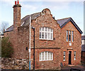
Former Council Offices, Wetheral - November 2016
Dated 1891 and marked on the OS Map as "Council Offices", this building appears to be out of use - although still in good internal condition.
Image: © The Carlisle Kid Taken: 28 Nov 2016
0.03 miles
2
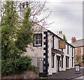
The Wheatsheaf, Wetheral - November 2016 (1)
Possibly dating from the 17th Century, the building became a public house in the early 19th century. Acquired by the State in October 1916, it returned to private ownership in 1973 and is still trading. See also: Image] , Image] and Image] . Photograph is for record only - I have no connection with this business and cannot advise on its products or services.
Image: © The Carlisle Kid Taken: 28 Nov 2016
0.04 miles
3
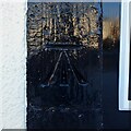
Benchmark, The Wheatsheaf Inn
Detail of the Ordnance Survey cut benchmark on the painted door jamb of the Wheatsheaf Inn in Wetheral. The benchmark marks a height of 63.268m above sea level (Ordnance Datum Newlyn) last verified in 1972 (location photograph Image).
Image: © Adrian Taylor Taken: 11 Feb 2021
0.04 miles
4
The Wheatsheaf Inn, Wetheral
The front door of the 19th century Wheatsheaf Inn in Wetheral. There is a large Ordnance Survey cut benchmark visible on the door jamb (photograph Image) below the blue notice which advises customers of the need to wear face masks due to the COVID-19 pandemic.
Image: © Adrian Taylor Taken: 11 Feb 2021
0.04 miles
5
Benchmark on door jamb of The Wheatsheaf pub
Ordnance Survey cut mark benchmark described on the Bench Mark Database at www.bench-marks.org.uk/bm137290
Image: © Roger Templeman Taken: 7 Sep 2021
0.04 miles
6
The Wheatsheaf on SE side of B6263
Image: © Luke Shaw Taken: 7 Sep 2021
0.04 miles
7
The Wheatsheaf, Wetheral - November 2016 (2)
See also: Image] , Image] and Image] .
Image: © The Carlisle Kid Taken: 28 Nov 2016
0.05 miles
8
The Wheatsheaf, Wetheral - November 2016 (3)
The back of the pub - see also: Image] , Image] and Image] .
Image: © The Carlisle Kid Taken: 28 Nov 2016
0.05 miles
9
The Wheatsheaf, Wetheral - November 2016 (4)
The pub sign - see also: Image] , Image] and Image] .
Image: © The Carlisle Kid Taken: 28 Nov 2016
0.05 miles
10
Roadworks outside The Wheatsheaf at bend in B6263
There is an Ordnance Survey benchmark Image on the near jamb of the pub's door under the pub sign
Image: © Roger Templeman Taken: 7 Sep 2021
0.06 miles
  • ...