IMAGES TAKEN NEAR TO
Beech Tree Farm, CARLISLE, CA4 8EJ
Introduction
This page details the photographs taken nearby to Beech Tree Farm, CA4 8EJ by members of the Geograph project.
The Geograph project started in 2005 with the aim of publishing, organising and preserving representative images for every square kilometre of Great Britain, Ireland and the Isle of Man.

There are currently over 7.5m images from over14,400 individuals and you can help contribute to the project by visiting https://www.geograph.org.uk
Image Map
Images are licensed for reuse under creativecommons.org/licenses/by-sa/2.0
Notes
- Clicking on the map will re-center to the selected point.
- The higher the marker number, the further away the image location is from the centre of the postcode.
Image Listing (45 Images Found)
Images are licensed for reuse under creativecommons.org/licenses/by-sa/2.0
Image
Details
Distance
1
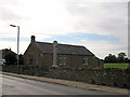
Chapel in Cumwhinton
The building stands alongside the village war memorial (see also Image] ). An absence of signs outside this building suggest that it may not be currently in use as a chapel. It is dated 1908.
Image: © Richard Dorrell
Taken: 25 Jul 2011
0.05 miles
2
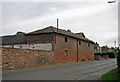
Substantial barn, Cumwhinton
Standing in the centre of the village of Cumwhinton. this barn and its associated farmyard are a strong reminder of the agricultural nature of the community.
Image: © Richard Dorrell
Taken: 25 Jul 2011
0.06 miles
3
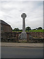
War memorial, Cumwhinton
The memorial is in memory of local people who were lost in both World Wars.
Image: © Richard Dorrell
Taken: 25 Jul 2011
0.07 miles
4
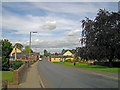
Cumwhinton village
A view along Steele's Bank, the main road through the village. In this direction, the road, which is the B6263, leads to Wetheral.
Image: © Richard Dorrell
Taken: 25 Jul 2011
0.09 miles
5
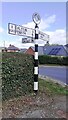
Cumberland County Council finger signpost at T-junction in Cumwhinton
The signpost has Milestone Society National ID: CU_NY4452A
Image: © Roger Templeman
Taken: 16 Sep 2021
0.10 miles
6
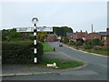
Old direction sign, Cumwhinton
On the B6263.
Lowther Arms Country Inn public house at the top of the road.
Image: © JThomas
Taken: 10 Oct 2015
0.11 miles
7
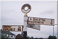
Direction Sign - Signpost on the B6263 in Cumwhinton
Annulus finial - 3 arms; Cumberland CC named halo by the B6263, in parish of Wetheral (Carlisle District), on the west side of the T junction in Cumwhinton.
Surveyed
Milestone Society National ID: CU_NY4452A
Image: © I Davison
Taken: Unknown
0.11 miles
8

OS Cut Mark - Cumwhinton, Rhudil House
https://www.bench-marks.org.uk/bm74938
Image: © thejackrustles
Taken: 31 Oct 2021
0.12 miles
9

Seat on the village green, Cumwhinton
In the background (on the right) is the Lowther Arms Inn (Image] ).
Image: © Richard Dorrell
Taken: 25 Jul 2011
0.12 miles
10
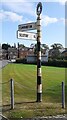
Cumberland County Council finger signpost at road fork on NW side of Cumwhinton
The signpost has Milestone Society National ID: CU_NY4452B
Image: © Roger Templeman
Taken: 16 Sep 2021
0.12 miles