IMAGES TAKEN NEAR TO
Wreay, CARLISLE, CA4 0RH
Introduction
This page details the photographs taken nearby to CA4 0RH by members of the Geograph project.
The Geograph project started in 2005 with the aim of publishing, organising and preserving representative images for every square kilometre of Great Britain, Ireland and the Isle of Man.

There are currently over 7.5m images from over14,400 individuals and you can help contribute to the project by visiting https://www.geograph.org.uk
Image Map
Images are licensed for reuse under creativecommons.org/licenses/by-sa/2.0
Notes
- Clicking on the map will re-center to the selected point.
- The higher the marker number, the further away the image location is from the centre of the postcode.
Image Listing (17 Images Found)
Images are licensed for reuse under creativecommons.org/licenses/by-sa/2.0
Image
Details
Distance
1
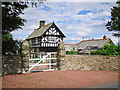
Woodside Lodge
Built around 1880 as the lodge to Woodside, a large country house. By the 1930s the mansion had fallen into disrepair and most of it was demolished, though one wing survives today as Woodside Park, the house next door (information from parish magazine http://www.stmaryswreay.org/wp-content/uploads/2014/05/Pinecone-4.pdf ).
The Woodside estate was owned for many years by the family of Sarah Losh https://en.wikipedia.org/wiki/Sara_Losh , who built St Mary's Church at Wreay http://www.stmaryswreay.org .
The lodge is a listed building - for architectural details see Images of England http://www.imagesofengland.org.uk/details/default.aspx?id=77625 .
See also Image .
Image: © Rose and Trev Clough
Taken: 5 Jul 2016
0.01 miles
2
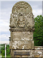
Gate pier at Woodside Lodge
For context see Image .
The gate piers are listed by Historic England as a separate item from the lodge - description here http://www.imagesofengland.org.uk/details/default.aspx?id=77626 .
Carved at the top is the coat of arms of the Losh family, generations of whom owned the extensive Woodside estate until the early 20th century. This is a zoom shot from the road, so difficult to make out details - it looks like the heads of three creatures (possibly falcons).
Image: © Rose and Trev Clough
Taken: 5 Jul 2016
0.02 miles
3
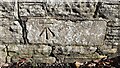
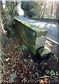
Benchmark on top of NE parapet of Woodside Bridge
Ordnance Survey rivet benchmark levelled at 57.062m above Newlyn Datum verified 1970 about 2m from NW end of parapet
Image: © Roger Templeman
Taken: 4 Nov 2021
0.13 miles
4
Benchmark on wall on NE side of road about 30m south of entrance to Woodside Park
Ordnance Survey cut mark benchmark on stone in wall
Image: © Roger Templeman
Taken: 4 Nov 2021
0.14 miles
5
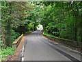
Woodside Bridge
On the road between Brisco and Wreay, crossing Woodside Beck.
Image: © Rose and Trev Clough
Taken: 5 Jul 2016
0.14 miles
6
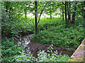
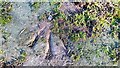
Woodside Beck
At the northern end of Low Hurst Wood. View from Woodside Bridge.
Lots of nettles down there.
Image: © Rose and Trev Clough
Taken: 5 Jul 2016
0.14 miles
7
Woodside Bridge taking road over Woodside Beck
There is an Ordnance Survey benchmark Image on top of the left hand parapet about 2m from its near end. There is also a bridge ownership marker stone at the end of the parapet
Image: © Roger Templeman
Taken: 4 Nov 2021
0.15 miles
8
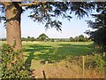
Parkland south of Carlisle
Seen from the road between Brisco and Wreay
Image: © Oliver Dixon
Taken: 19 Jul 2006
0.16 miles
9

Rural road passing entrance to Woodside Park
There is an Ordnance Survey benchmark Image on a stone in the wall marked by a notebook positioned beside it
Image: © Roger Templeman
Taken: 4 Nov 2021
0.17 miles
10
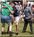
Cumberland Wrestling at the Cumberland Show - June 2017 (1)
Also known as Cumberland & Westmorland Wrestling, the origins of the sport are a matter for debate and are probably best explained on Wikipedia at: https://en.wikipedia.org/wiki/Cumberland_and_Westmorland_wrestling
After an hour of junior events (which were not photographed), the preliminary bouts ended with the two finalists in the "Under 18" category. The official in the grey top is the referee.
Location is approximate.
Image: © The Carlisle Kid
Taken: 17 Jun 2017
0.22 miles