IMAGES TAKEN NEAR TO
Sowerby Row, CARLISLE, CA4 0QG
Introduction
This page details the photographs taken nearby to CA4 0QG by members of the Geograph project.
The Geograph project started in 2005 with the aim of publishing, organising and preserving representative images for every square kilometre of Great Britain, Ireland and the Isle of Man.

There are currently over 7.5m images from over14,400 individuals and you can help contribute to the project by visiting https://www.geograph.org.uk
Image Map
Images are licensed for reuse under creativecommons.org/licenses/by-sa/2.0
Notes
- Clicking on the map will re-center to the selected point.
- The higher the marker number, the further away the image location is from the centre of the postcode.
Image Listing (5 Images Found)
Images are licensed for reuse under creativecommons.org/licenses/by-sa/2.0
Image
Details
Distance
1
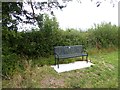
Roadside seat
Commemorating Sowerby Row Sports, 2012.
Image: © Oliver Dixon
Taken: 1 Aug 2018
0.14 miles
2
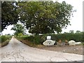
Driveway to Ratten Castle Farm
With a small installation by the entrance.
Image: © Oliver Dixon
Taken: 1 Aug 2018
0.15 miles
4
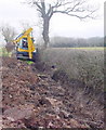
Ditching
An important part of the infrastructure of farmland. If the council won't do it, it's down to the farmer, as here.
Image: © Bob Jenkins
Taken: 24 Feb 2006
0.17 miles
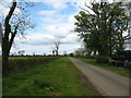
5

Minor road at the entrance to Roe Head
Looking south-eastward.
Image: © Peter Wood
Taken: 26 Sep 2020
0.21 miles