IMAGES TAKEN NEAR TO
Ivegill, CARLISLE, CA4 0QF
Introduction
This page details the photographs taken nearby to CA4 0QF by members of the Geograph project.
The Geograph project started in 2005 with the aim of publishing, organising and preserving representative images for every square kilometre of Great Britain, Ireland and the Isle of Man.

There are currently over 7.5m images from over14,400 individuals and you can help contribute to the project by visiting https://www.geograph.org.uk
Image Map
Images are licensed for reuse under creativecommons.org/licenses/by-sa/2.0
Notes
- Clicking on the map will re-center to the selected point.
- The higher the marker number, the further away the image location is from the centre of the postcode.
Image Listing (6 Images Found)
Images are licensed for reuse under creativecommons.org/licenses/by-sa/2.0
Image
Details
Distance
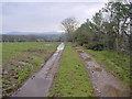
2
Green lane near Intack House, Middlesceugh
Status bridleway.
Image: © Oliver Dixon
Taken: 1 Aug 2018
0.15 miles
3
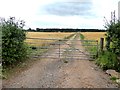
Farm track and field of barley near Roebanks.
Image: © Oliver Dixon
Taken: 1 Aug 2018
0.17 miles
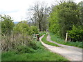
5
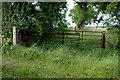
Y-junction of bridleway and footpath
The bridleway goes off on the right of the picture, running NNW towards Thistlewood. The yellow arrow sign is visible.
The footpath that crosses the square diagonally to the NW goes off to the left of the picture. The small sign is visible near the top of the grey coloured post.
Image: © Phil Davies
Taken: 28 Jul 2007
0.21 miles