IMAGES TAKEN NEAR TO
Southwaite, CARLISLE, CA4 0PY
Introduction
This page details the photographs taken nearby to CA4 0PY by members of the Geograph project.
The Geograph project started in 2005 with the aim of publishing, organising and preserving representative images for every square kilometre of Great Britain, Ireland and the Isle of Man.

There are currently over 7.5m images from over14,400 individuals and you can help contribute to the project by visiting https://www.geograph.org.uk
Image Map
Images are licensed for reuse under creativecommons.org/licenses/by-sa/2.0
Notes
- Clicking on the map will re-center to the selected point.
- The higher the marker number, the further away the image location is from the centre of the postcode.
Image Listing (7 Images Found)
Images are licensed for reuse under creativecommons.org/licenses/by-sa/2.0
Image
Details
Distance
1

View across a field to Beckstones Farm
The ears of this cereal crop have long whiskers, so we'll guess it's barley.
Image: © Rose and Trev Clough
Taken: 12 Jul 2016
0.01 miles
2
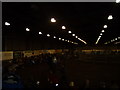
Indoor Arena at Greenlands Equestrian Centre
The picture's very dark, sorry.
Image: © Darrin Antrobus
Taken: 18 Oct 2007
0.04 miles
7
Beckhouse Bridge
The bridge crosses a little stream, not much to see over the parapet.
Image: © Rose and Trev Clough
Taken: 12 Jul 2016
0.24 miles