IMAGES TAKEN NEAR TO
Ivegill, CARLISLE, CA4 0PW
Introduction
This page details the photographs taken nearby to CA4 0PW by members of the Geograph project.
The Geograph project started in 2005 with the aim of publishing, organising and preserving representative images for every square kilometre of Great Britain, Ireland and the Isle of Man.

There are currently over 7.5m images from over14,400 individuals and you can help contribute to the project by visiting https://www.geograph.org.uk
Image Map
Images are licensed for reuse under creativecommons.org/licenses/by-sa/2.0
Notes
- Clicking on the map will re-center to the selected point.
- The higher the marker number, the further away the image location is from the centre of the postcode.
Image Listing (5 Images Found)
Images are licensed for reuse under creativecommons.org/licenses/by-sa/2.0
Image
Details
Distance
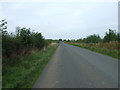
1
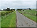
Country lane approaching Arnold House
Typical of the straight lanes which criss-cross the countryside to the south of Carlisle. The escarpment of the North Pennines beyond the Eden valley can be seen on the horizon.
Image: © Oliver Dixon
Taken: 27 May 2011
0.03 miles
2
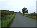
Minor road heading north west towards Carlisle
Lalbus Plantation in the distance.
Image: © JThomas
Taken: 10 Oct 2015
0.16 miles
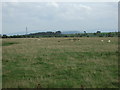
5
Heading north west near Oak Tree
Towards Carlisle.
Image: © JThomas
Taken: 10 Oct 2015
0.22 miles