IMAGES TAKEN NEAR TO
Ivegill, CARLISLE, CA4 0PR
Introduction
This page details the photographs taken nearby to CA4 0PR by members of the Geograph project.
The Geograph project started in 2005 with the aim of publishing, organising and preserving representative images for every square kilometre of Great Britain, Ireland and the Isle of Man.

There are currently over 7.5m images from over14,400 individuals and you can help contribute to the project by visiting https://www.geograph.org.uk
Image Map (Loading...)


Getting Data...Please wait
Leaflet Map data © OpenStreetMap
Images are licensed for reuse under creativecommons.org/licenses/by-sa/2.0
Notes
- Clicking on the map will re-center to the selected point.
- The higher the marker number, the further away the image location is from the centre of the postcode.
Image Listing (7 Images Found)
Images are licensed for reuse under creativecommons.org/licenses/by-sa/2.0
Image
Details
Distance
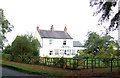
1
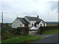
Rigg House
Cottage at the entrance of the drive to Bellmont Farm.
Image: © Oliver Dixon
Taken: 27 May 2011
0.00 miles
4
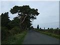
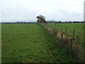
Minor road towards Carlisle
Heading north west near Fell View.
Image: © JThomas
Taken: 10 Oct 2015
0.16 miles