IMAGES TAKEN NEAR TO
Ivegill, CARLISLE, CA4 0PQ
Introduction
This page details the photographs taken nearby to CA4 0PQ by members of the Geograph project.
The Geograph project started in 2005 with the aim of publishing, organising and preserving representative images for every square kilometre of Great Britain, Ireland and the Isle of Man.

There are currently over 7.5m images from over14,400 individuals and you can help contribute to the project by visiting https://www.geograph.org.uk
Image Map
Images are licensed for reuse under creativecommons.org/licenses/by-sa/2.0
Notes
- Clicking on the map will re-center to the selected point.
- The higher the marker number, the further away the image location is from the centre of the postcode.
Image Listing (12 Images Found)
Images are licensed for reuse under creativecommons.org/licenses/by-sa/2.0
Image
Details
Distance
1
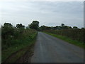
Minor road near Swathwaite Head
Heading south west.
Image: © JThomas
Taken: 10 Oct 2015
0.09 miles
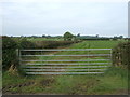
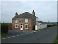
3
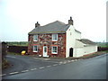
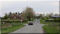
Meadow View
The minor road to the left goes to Stockwathdale.
Image: © Alexander P Kapp
Taken: 9 Feb 2007
0.16 miles
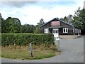
6
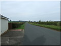
Minor road near Sycamore Villa
Heading north west towards Carlisle.
Image: © JThomas
Taken: 10 Oct 2015
0.18 miles