IMAGES TAKEN NEAR TO
The Grange, CARLISLE, CA4 0PE
Introduction
This page details the photographs taken nearby to The Grange, CA4 0PE by members of the Geograph project.
The Geograph project started in 2005 with the aim of publishing, organising and preserving representative images for every square kilometre of Great Britain, Ireland and the Isle of Man.

There are currently over 7.5m images from over14,400 individuals and you can help contribute to the project by visiting https://www.geograph.org.uk
Image Map (Loading...)


Getting Data...Please wait
Leaflet Map data © OpenStreetMap
Images are licensed for reuse under creativecommons.org/licenses/by-sa/2.0
Notes
- Clicking on the map will re-center to the selected point.
- The higher the marker number, the further away the image location is from the centre of the postcode.
Image Listing (6 Images Found)
Images are licensed for reuse under creativecommons.org/licenses/by-sa/2.0
Image
Details
Distance
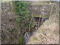
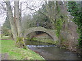
1
Pack horse bridge over the River Ive
Seemingly now a private bridge.
Image: © Oliver Dixon
Taken: 1 Aug 2018
0.09 miles
2
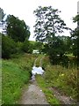
Ford over the River Ive and Ivegill
By the looks of it, only used by farm traffic.
Image: © Oliver Dixon
Taken: 1 Aug 2018
0.12 miles
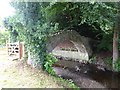
3
Packhorse Bridge
Simply named Ivegill Bridge on maps, a local resident reckons it's "donkeys years" old...
Image: © Bob Jenkins
Taken: 24 Feb 2006
0.14 miles
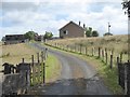
4
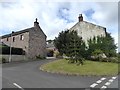
Courtyard development at Ivegill
With a monkey puzzle tree in the foreground.
Image: © Oliver Dixon
Taken: 1 Aug 2018
0.14 miles