IMAGES TAKEN NEAR TO
Southwaite, CARLISLE, CA4 0ND
Introduction
This page details the photographs taken nearby to CA4 0ND by members of the Geograph project.
The Geograph project started in 2005 with the aim of publishing, organising and preserving representative images for every square kilometre of Great Britain, Ireland and the Isle of Man.

There are currently over 7.5m images from over14,400 individuals and you can help contribute to the project by visiting https://www.geograph.org.uk
Image Map
Images are licensed for reuse under creativecommons.org/licenses/by-sa/2.0
Notes
- Clicking on the map will re-center to the selected point.
- The higher the marker number, the further away the image location is from the centre of the postcode.
Image Listing (7 Images Found)
Images are licensed for reuse under creativecommons.org/licenses/by-sa/2.0
Image
Details
Distance
1
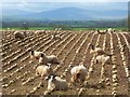
Farmland, Hesket
Sheep and turnips with Skiddaw, Carrock Fell and High Pike in the background (from left to right).
Image: © Andrew Smith
Taken: 8 Apr 2014
0.10 miles
2
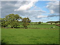
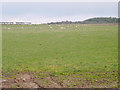
Inglewood grassland
Grassland for pasture and winter feeding occupies most of the fields in this area. The first cut of silage was well under way.
Image: © Mary and Angus Hogg
Taken: 18 May 2022
0.19 miles
3
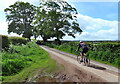
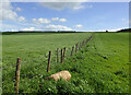
Cycling near Calthwaite
These minor rural roads provide popular routes for cyclists.
Image: © Mary and Angus Hogg
Taken: 18 May 2022
0.20 miles
5
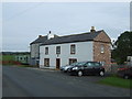
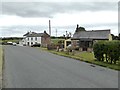
House, Market Gate
Shown as a public house on old maps.
Image: © JThomas
Taken: 10 Oct 2015
0.22 miles