IMAGES TAKEN NEAR TO
Southwaite, CARLISLE, CA4 0LT
Introduction
This page details the photographs taken nearby to CA4 0LT by members of the Geograph project.
The Geograph project started in 2005 with the aim of publishing, organising and preserving representative images for every square kilometre of Great Britain, Ireland and the Isle of Man.

There are currently over 7.5m images from over14,400 individuals and you can help contribute to the project by visiting https://www.geograph.org.uk
Image Map
Images are licensed for reuse under creativecommons.org/licenses/by-sa/2.0
Notes
- Clicking on the map will re-center to the selected point.
- The higher the marker number, the further away the image location is from the centre of the postcode.
Image Listing (9 Images Found)
Images are licensed for reuse under creativecommons.org/licenses/by-sa/2.0
Image
Details
Distance
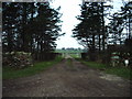
3
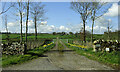
Sceugh Farm
This is not the main access road for Sceugh. A shorter route comes in from the west.
Image: © Mary and Angus Hogg
Taken: 2 Apr 2022
0.11 miles
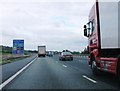
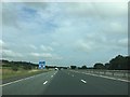
5
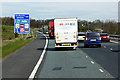
Northbound M6 approaching Southwaite Services
Image: © David Dixon
Taken: 3 Apr 2017
0.12 miles
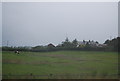
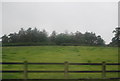
7
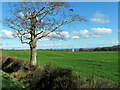
Petteril Hill farmland
The M6 lies on the other side of this field.
Image: © Mary and Angus Hogg
Taken: 2 Apr 2022
0.16 miles