IMAGES TAKEN NEAR TO
Southwaite, CARLISLE, CA4 0JH
Introduction
This page details the photographs taken nearby to CA4 0JH by members of the Geograph project.
The Geograph project started in 2005 with the aim of publishing, organising and preserving representative images for every square kilometre of Great Britain, Ireland and the Isle of Man.

There are currently over 7.5m images from over14,400 individuals and you can help contribute to the project by visiting https://www.geograph.org.uk
Image Map
Images are licensed for reuse under creativecommons.org/licenses/by-sa/2.0
Notes
- Clicking on the map will re-center to the selected point.
- The higher the marker number, the further away the image location is from the centre of the postcode.
Image Listing (13 Images Found)
Images are licensed for reuse under creativecommons.org/licenses/by-sa/2.0
Image
Details
Distance
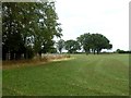
2
Grass field, Hesket
View towards Blencathra.
Image: © Richard Webb
Taken: 28 Jun 2014
0.06 miles
3
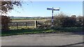
Gateway to field at rural T-junction near Ling Croft
Image: © Roger Templeman
Taken: 13 Nov 2021
0.07 miles
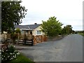
4
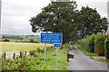
Warning at Ling Cottages
On this September day, the ford would be even deeper than usual.
Image: © Trevor Harris
Taken: 6 Sep 2008
0.13 miles
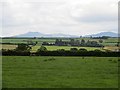
5
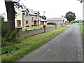
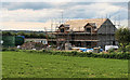
Ling Hurst and Ling Cottages
Ling Hurst, the nearest house, can be seen under construction in Image
Image: © Oliver Dixon
Taken: 1 Aug 2018
0.14 miles
6
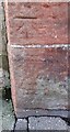
Benchmark on Ling Cottages
Ordnance Survey cut mark benchmark levelled at 128.550m above Newlyn Datum verified 1970
Image: © Roger Templeman
Taken: 13 Nov 2021
0.14 miles
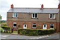
8
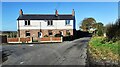
Ling Cottages at T-junction
There is an Ordnance Survey benchmark Image on the side of the right hand cottage at its front corner
Image: © Roger Templeman
Taken: 13 Nov 2021
0.15 miles