IMAGES TAKEN NEAR TO
Low Hesket, CARLISLE, CA4 0HP
Introduction
This page details the photographs taken nearby to CA4 0HP by members of the Geograph project.
The Geograph project started in 2005 with the aim of publishing, organising and preserving representative images for every square kilometre of Great Britain, Ireland and the Isle of Man.

There are currently over 7.5m images from over14,400 individuals and you can help contribute to the project by visiting https://www.geograph.org.uk
Image Map
Images are licensed for reuse under creativecommons.org/licenses/by-sa/2.0
Notes
- Clicking on the map will re-center to the selected point.
- The higher the marker number, the further away the image location is from the centre of the postcode.
Image Listing (20 Images Found)
Images are licensed for reuse under creativecommons.org/licenses/by-sa/2.0
Image
Details
Distance
1
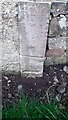
Benchmark on stone in wall on NE side of A6 outside Court Thorn Surgery
Ordnance Survey cut mark benchmark levelled at 128.568m above Newlyn Datum verified 1969
Image: © Roger Templeman
Taken: 10 Nov 2021
0.01 miles
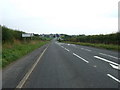
3
Court Thorn Surgery on NE side of A6
There is an Ordnance Survey benchmark Image on the vertical stone in the stone wall in the left hand foreground
Image: © Roger Templeman
Taken: 10 Nov 2021
0.01 miles

5
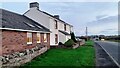
Old Milestone by the A6, south of Low Hesket
Metal plates attached to stone post by the A6, in parish of HESKET (EDEN District), on the verge on the east side of the A6 between Low Hesket and High Hesket, 65 metres south-southeast of Court Thorn Surgery. Carlisle red stone numeral, erected by the Carlisle & Eamont Bridge turnpike trust in the 19th century.
Inscription reads:-
: 10 : : 8 :
Milestone Society National ID: CU_PRCL10
Image: © CF Smith
Taken: 2 Dec 2009
0.04 miles
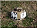
6

Milestone (Penrith 10, Carlisle 8) on northeast side of A6 SE of Court Thorn
There is an Ordnance Survey pivot benchmark on top of the stone. The mark was levelled at 127.425 Newlyn Datum verified in 1969, and previously levelled at 417.558 feet above Liverpool Datum during the 1841/4 Liverpool to Port Carlisle 1GL Survey. The surveyor's description was 'No. 438. Mark on top of the 10th milestone from Penrith ; 2.24 ft. above surface of road'
Image: © Roger Templeman
Taken: 10 Nov 2021
0.05 miles
7
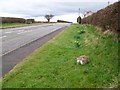
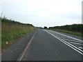
A6 and milestone, High Hesket
Milestone beside the A6.
Milestones are the original roadside heritage features with many dating back hundreds of years and these historic items are under threat from highway developments.
Image: © Maigheach-gheal
Taken: 5 Apr 2010
0.05 miles
8
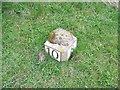
Milestone, High Hesket
The milestone has an eroded bench mark on the top. For a wider view of the stone Image and http://www.bench-marks.org.uk/bm34456
Milestones did not come into general use until the Turnpike Act of 1766 made them compulsory on turnpike roads, these roads were built by private enterprise under licence from the Government and maintained by tolls on those who used them. Before this Act milestones were put up occasionally, often as charitable acts and commemorations. Many Turnpike Act stones still exist. They are usually 2-3 ft high, with the initial letter or abbreviation of the nearest market town show on two faces, and the distance from it.
A bench mark is an Ordnance Survey arrowhead sign found on walls, bridges, churches and specially erected triangulation pillars where the altitude above sea-level has been accurately measured by surveyors. The arrowhead points to a horizontal line above it which marks the exact altitude.
With rivets and pivots there is no datum (horizontal line) cut, the pointed-to horizontal surface defining the datum height.
Image: © Maigheach-gheal
Taken: 5 Apr 2010
0.05 miles