IMAGES TAKEN NEAR TO
The Lane, CARLISLE, CA4 0EX
Introduction
This page details the photographs taken nearby to The Lane, CA4 0EX by members of the Geograph project.
The Geograph project started in 2005 with the aim of publishing, organising and preserving representative images for every square kilometre of Great Britain, Ireland and the Isle of Man.

There are currently over 7.5m images from over14,400 individuals and you can help contribute to the project by visiting https://www.geograph.org.uk
Image Map
Images are licensed for reuse under creativecommons.org/licenses/by-sa/2.0
Notes
- Clicking on the map will re-center to the selected point.
- The higher the marker number, the further away the image location is from the centre of the postcode.
Image Listing (32 Images Found)
Images are licensed for reuse under creativecommons.org/licenses/by-sa/2.0
Image
Details
Distance
2
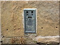
Ordnance Survey Flush Bracket 1545
The bracket can be found on the roadside wall of a house in Low Hesket.
This benchmark has a recorded height of 98.61 metres above sea level.
For more detail see : https://www.bench-marks.org.uk/bm2436
Image: © Peter Wood
Taken: 11 Jul 2020
0.03 miles
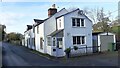
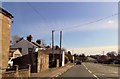
3
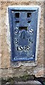
Benchmark on 'Woodside'
Ordnance Survey flush bracket (serial number 1545) benchmark levelled at 98.610m above Newlyn Datum in 1952 and verified in 1972
Image: © Roger Templeman
Taken: 10 Nov 2021
0.03 miles
4
'Woodside' on north side of street
There is an Ordnance Survey flush bracket benchmark Image on the right hand face of the house, just above pavement level, at its near corner
Image: © Roger Templeman
Taken: 10 Nov 2021
0.03 miles
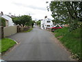
5
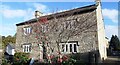
Nos. 1 and 2 Stoney Mount
On north side of road from A6 towards Barrock End
Image: © Luke Shaw
Taken: 10 Nov 2021
0.04 miles
7
Minor road near to castle Farm, Low Hesket
Looking westward.
Image: © Peter Wood
Taken: 11 Jul 2020
0.04 miles
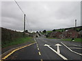
8
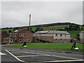
A6, Low Hesket
Heading south east towards Penrith.
Image: © JThomas
Taken: 10 Oct 2015
0.05 miles
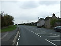
10
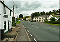
The A6 in Low Hesket
The A6 is comparatively quiet now that most of the traffic uses the M6, but the Rose and Crown has survived, and serves meals.
Image: © Humphrey Bolton
Taken: 4 Jul 2021
0.07 miles