IMAGES TAKEN NEAR TO
Cumwhinton, CARLISLE, CA4 0AS
Introduction
This page details the photographs taken nearby to CA4 0AS by members of the Geograph project.
The Geograph project started in 2005 with the aim of publishing, organising and preserving representative images for every square kilometre of Great Britain, Ireland and the Isle of Man.

There are currently over 7.5m images from over14,400 individuals and you can help contribute to the project by visiting https://www.geograph.org.uk
Image Map
Images are licensed for reuse under creativecommons.org/licenses/by-sa/2.0
Notes
- Clicking on the map will re-center to the selected point.
- The higher the marker number, the further away the image location is from the centre of the postcode.
Image Listing (12 Images Found)
Images are licensed for reuse under creativecommons.org/licenses/by-sa/2.0
Image
Details
Distance
1
House at Parkhead Farm on NE side of Peter Gate
Image: © Roger Templeman
Taken: 9 Sep 2021
0.00 miles
3
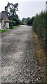
Trackbed of former tramway line crossing Peter Gate
The railway connected the Cocklakes gypsum mine to the Settle-Carlisle mainline SE of Cumwhinton Station
Image: © Luke Shaw
Taken: 9 Sep 2021
0.13 miles
4
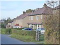
Houses on Peter Gate
A small row of houses on the road north of Cotehill.
Image: © Oliver Dixon
Taken: 25 Oct 2016
0.14 miles
6
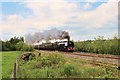
46233 'Duchess of Sutherland'
'Duchess of Sutherland' hauls the 'Cumbrian Mountain Express' steam rail excursion southbound along the Settle & Carlisle line at the former Howe & Co. Siding between Cumwhinton and Cotehill. Gypsum was mined by John Howe at nearby Cocklakes and transported by tramway to the siding.
Image: © Greg Fitchett
Taken: 14 Jun 2012
0.19 miles
7
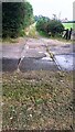
Rails in road at former level crossing of Cocklakes tramway
Image: © Roger Templeman
Taken: 9 Sep 2021
0.19 miles
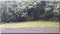
8
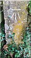
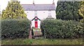
Benchmark on gatepost at track entrance from bend in road
Ordnance Survey cut mark benchmark levelled at 73.003m above Newlyn Datum verified 1972
Image: © Roger Templeman
Taken: 9 Sep 2021
0.20 miles
9
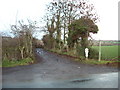
Gateway to blocked track from road bend near Bentinck Cottage
There is an Ordnance Survey benchmark Image on the inside face of the gatepost at the right hand side of the gate. The track has been blocked because of subsidence danger arising from gypsum mining
Image: © Roger Templeman
Taken: 9 Sep 2021
0.20 miles
10
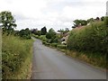
Scattered houses, Peter Gate
Very much a linear settlement pattern, south of Cumwhinton.
Image: © Richard Webb
Taken: 28 Jun 2014
0.21 miles