IMAGES TAKEN NEAR TO
Deer Park Road, CARLISLE, CA3 9RW
Introduction
This page details the photographs taken nearby to Deer Park Road, CA3 9RW by members of the Geograph project.
The Geograph project started in 2005 with the aim of publishing, organising and preserving representative images for every square kilometre of Great Britain, Ireland and the Isle of Man.

There are currently over 7.5m images from over14,400 individuals and you can help contribute to the project by visiting https://www.geograph.org.uk
Image Map
Images are licensed for reuse under creativecommons.org/licenses/by-sa/2.0
Notes
- Clicking on the map will re-center to the selected point.
- The higher the marker number, the further away the image location is from the centre of the postcode.
Image Listing (23 Images Found)
Images are licensed for reuse under creativecommons.org/licenses/by-sa/2.0
Image
Details
Distance
1
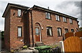
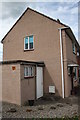
Nos. 4 and 2 Dixon Road
There is an OS benchmark Image on the left hand side of #4 at its front corner
Image: © Roger Templeman
Taken: 24 Jul 2015
0.08 miles
2
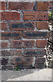
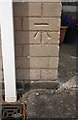
Benchmark on #4 Dixon Road
Ordnance Survey cut mark benchmark described on the Bench Mark Database at http://www.bench-marks.org.uk/bm69414
Image: © Roger Templeman
Taken: 24 Jul 2015
0.08 miles
3
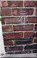
Benchmark on #19 Belah Road
Ordnance Survey cut mark benchmark described on the Bench Mark Database at http://www.bench-marks.org.uk/bm69418
Image: © Roger Templeman
Taken: 24 Jul 2015
0.12 miles
4
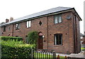
Semi-detached houses on Belah Road
There is an OS benchmark Image on the right hand side of the right hand house, near its front corner
Image: © Roger Templeman
Taken: 24 Jul 2015
0.12 miles
5
#1 Ash Grove
There is an OS benchmark Image at the right hand corner of the house, right of the white downpipe
Image: © Roger Templeman
Taken: 24 Jul 2015
0.12 miles
6
Benchmark on #1 Ash Grove
Ordnance Survey cut mark benchmark described on the Bench Mark Database at http://www.bench-marks.org.uk/bm69417
Image: © Roger Templeman
Taken: 24 Jul 2015
0.12 miles
7
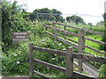
Kingmoor Sidings Nature Reserve
The Northern Entrance To Kingmoor Sidings accessed at the bottom of Kingmoor Road.
Image: © Andy Connor
Taken: 8 Jun 2008
0.14 miles
8

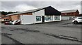
Vibralife Health Club & Fitness Clinic, Kingmoor Road
There is an OS benchmark Image on the near corner of the building between the left hand two bicycle supports
Image: © Roger Templeman
Taken: 24 Jul 2015
0.15 miles
9

Benchmark on Vibralife Health Club
Ordnance Survey cut mark benchmark described on the Bench Mark Database at http://www.bench-marks.org.uk/bm69528
Image: © Roger Templeman
Taken: 24 Jul 2015
0.16 miles
10
VLAesthtics premises on SW side of Kingmoor Road
There is an Ordnance Survey benchmark Image on the front of the building
Image: © Luke Shaw
Taken: 17 Aug 2021
0.16 miles