IMAGES TAKEN NEAR TO
Etterby, CARLISLE, CA3 9QS
Introduction
This page details the photographs taken nearby to CA3 9QS by members of the Geograph project.
The Geograph project started in 2005 with the aim of publishing, organising and preserving representative images for every square kilometre of Great Britain, Ireland and the Isle of Man.

There are currently over 7.5m images from over14,400 individuals and you can help contribute to the project by visiting https://www.geograph.org.uk
Image Map (Loading...)


Getting Data...Please wait
Leaflet Map data © OpenStreetMap
Images are licensed for reuse under creativecommons.org/licenses/by-sa/2.0
Notes
- Clicking on the map will re-center to the selected point.
- The higher the marker number, the further away the image location is from the centre of the postcode.
Image Listing (61 Images Found)
Images are licensed for reuse under creativecommons.org/licenses/by-sa/2.0
Image
Details
Distance
1
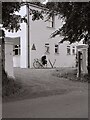
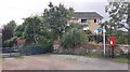
Carlisle Youth Hostel, 1977
Etterby House, belonging to the Youth Hostels Association, operated as Carlisle's youth hostel from 1953 to 1997. Now private housing Image
Image: © Richard Sutcliffe
Taken: Unknown
0.01 miles
2
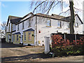
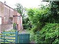
Former Youth Hostel, Etterby Road
This was Etterby House, belonging to the Youth Hostels Association (see Wikipedia https://en.wikipedia.org/wiki/Youth_Hostels_Association_(England_%26_Wales) ) from 1953 to 1997. It has since been converted to several individual properties, and renamed Eden Bank.
Before being purchased by the YHA, it had been a private residence (with fishing rights) - in 1861 it was occupied by George Relph, magistrate and draper (Carlisle Encyclopaedia http://www.carlisleshistory.co.uk/page27.htm ).
Image: © Rose and Trev Clough
Taken: 1 Mar 2017
0.01 miles
3
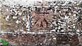
Benchmark on wall bounding #1 Stainton Road
Ordnance Survey cut mark benchmark levelled at 19.640m above Newlyn Datum verified 1972
Image: © Roger Templeman
Taken: 12 Jul 2021
0.04 miles
4
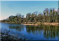
River Eden View
Looking downstream from the riverside path on a chilly but bright late-January morning.
Image: © Mary and Angus Hogg
Taken: 31 Jan 2015
0.04 miles
5
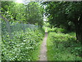
Footpath to River Eden at entrance to Wath Cottage
There is an Ordnance Survey benchmark Image on the wall about two feet left of the footpath sign pole
Image: © Roger Templeman
Taken: 12 Jul 2021
0.05 miles
6
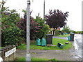
Stainton Road, Carlisle
On bin day (Wed)
Image: © Alex McGregor
Taken: 14 Jul 2010
0.06 miles
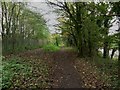
8
Footpath, River Eden
River Eden Footpath & Cycle Way
Image: © Andy Connor
Taken: 8 Jun 2008
0.07 miles
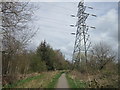
10
Path by the River Eden, Carlisle
A footpath on the southern bank of the River Eden in Carlisle. The Hadrian's Wall Long distance footpath follows the right of way.
Image: © Graham Robson
Taken: 30 Oct 2014
0.09 miles