IMAGES TAKEN NEAR TO
Cavendish Terrace, CARLISLE, CA3 9NE
Introduction
This page details the photographs taken nearby to Cavendish Terrace, CA3 9NE by members of the Geograph project.
The Geograph project started in 2005 with the aim of publishing, organising and preserving representative images for every square kilometre of Great Britain, Ireland and the Isle of Man.

There are currently over 7.5m images from over14,400 individuals and you can help contribute to the project by visiting https://www.geograph.org.uk
Image Map
Images are licensed for reuse under creativecommons.org/licenses/by-sa/2.0
Notes
- Clicking on the map will re-center to the selected point.
- The higher the marker number, the further away the image location is from the centre of the postcode.
Image Listing (179 Images Found)
Images are licensed for reuse under creativecommons.org/licenses/by-sa/2.0
Image
Details
Distance
1
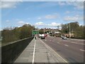
Eden Bridge, Carlisle
Eden Bridge carries the main A7 road northwards from Carlisle City Centre; it is also the route of the Cumbria Coastal Way.
Image: © Adrian Taylor
Taken: 20 Apr 2010
0.03 miles
2
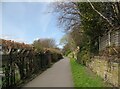
Footpath near Carlisle Cricket Ground
Between the Cricket Ground and properties bordering Cavendish Terrace, this public footpath provides a shortcut between Eden Bridge and Etterby Scaur.
This is the route of The Cumbria Coastal Way.
Image: © Adrian Taylor
Taken: 20 Apr 2010
0.05 miles
3
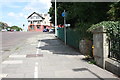
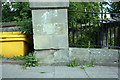
A7 junction, Stanwix Bank
There is an OS benchmark Image on the wall pier near the right hand edge of the image
Image: © Roger Templeman
Taken: 24 Jul 2015
0.05 miles
4
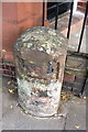
Benchmark on milestone, Scotland Road
Ordnance Survey rivet benchmark described on the Bench Mark Database at http://www.bench-marks.org.uk/bm30935
Image: © Roger Templeman
Taken: 30 Jul 2011
0.05 miles
5
Milestone beside A7 at Brampton Road junction
The milestone has been restored since 2011 Image with its OS benchmark remaining intact
Image: © Roger Templeman
Taken: 18 Jul 2015
0.05 miles
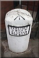
6
Old Milestone by the A7 in Carlisle
The milestone is located by Stanwix Bank House, on the pavement on the east side of the road. Parish of Stanwix Rural (Carlisle District). Stone post (plate lost and replaced), Carlisle round iron plate design, erected by the Kingstown & Westlinton Bridge turnpike trust in the 19th century. For an earlier image without a plate, see https://www.geograph.org.uk/photo/5622996
Inscription reads:-
CARLISLE
½ MILE {hand>}
GLASGOW
{
Image: © Tim Pugh
Taken: 1 Aug 2016
0.05 miles
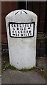
7
Old Milestone by the A7 in Carlisle
The milestone is located beside Stanwix Bank House, at the junction with Bampton Road, in the pavement with back to steps with rails leading to door, on the east side of the road. Parish of Carlisle (Carlisle District. Stone post (plate lost), Carlisle round iron plate design, erected by the Kingstown & Westlinton Bridge turnpike trust in the 19th century. For a later image with a replacement plate, see https://www.geograph.org.uk/photo/5622987
Inscription once read:-
(CARLISLE)
(½ MILE)
(GLASGOW)
(94 MILES)
Carved benchmark and rivet on top
Milestone Society National ID: CU_CLLT01
Image: © Colin Smith
Taken: Unknown
0.05 miles
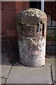
8
Old Milestone by the A7 in Carlisle
The milestone is located beside Stanwix Bank House, at the junction with Bampton Road, in the pavement with back to steps with rails leading to door, on the east side of the road. Parish of Carlisle (Carlisle District. Stone post (plate lost), Carlisle round iron plate design, erected by the Kingstown & Westlinton Bridge turnpike trust in the 19th century.
Inscription reads:-
CARLISLE
½ MILE
GLASGOW
94 MILES
Carved benchmark and rivet on top
Milestone Society National ID: CU_CLLT01
Image: © Barbara Todd
Taken: 7 Sep 2023
0.05 miles
9
Benchmark on wall pier on Stanwix Bank
Ordnance Survey cut mark benchmark described on the Bench Mark Database at http://www.bench-marks.org.uk/bm38808
Image: © Roger Templeman
Taken: 30 Jul 2011
0.06 miles
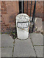
10
Junction of A7 and B6264
There is a milestone Image beside the A7 on the left hand side of the building which is University of Cumbria housing
Image: © Roger Templeman
Taken: 18 Jul 2015
0.06 miles