IMAGES TAKEN NEAR TO
Etterby Lea Road, CARLISLE, CA3 9JW
Introduction
This page details the photographs taken nearby to Etterby Lea Road, CA3 9JW by members of the Geograph project.
The Geograph project started in 2005 with the aim of publishing, organising and preserving representative images for every square kilometre of Great Britain, Ireland and the Isle of Man.

There are currently over 7.5m images from over14,400 individuals and you can help contribute to the project by visiting https://www.geograph.org.uk
Image Map
Images are licensed for reuse under creativecommons.org/licenses/by-sa/2.0
Notes
- Clicking on the map will re-center to the selected point.
- The higher the marker number, the further away the image location is from the centre of the postcode.
Image Listing (71 Images Found)
Images are licensed for reuse under creativecommons.org/licenses/by-sa/2.0
Image
Details
Distance
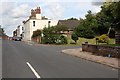
3
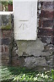
Benchmark on #10 Eden Place
Ordnance Survey cut mark benchmark described on the Bench Mark Database at http://www.bench-marks.org.uk/bm30943
Image: © Roger Templeman
Taken: 24 Jul 2015
0.05 miles
4
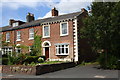
Eden Place houses
There is an OS benchmark Image on the corner, right hand face, of the nearest house
Image: © Roger Templeman
Taken: 24 Jul 2015
0.05 miles
5
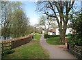
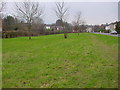
Footpath near the River Eden
Between Eden Place and the River Eden this public footpath provides a pleasant shortcut between Eden Bridge and Etterby Scaur. This is the route of The Cumbria Coastal Way.
Image: © Adrian Taylor
Taken: 20 Apr 2010
0.09 miles
6
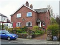
Houses built for army veterans
A closer look at the front of this pair of houses in Etterby Street reveals their origin - see Image .
Dated 1905, according to Carlisle Encyclopaedia http://www.carlisleshistory.co.uk/page27.htm they were for soldiers disabled in the Boer War.
One of the houses was sold freehold in 1996, but we do not know if the regimental charity still has an interest in the adjoining property.
Image: © Rose and Trev Clough
Taken: 27 Apr 2016
0.09 miles
7
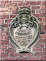
Plaque - Border Regiment Cottage Homes
Located on the front wall of semi-detached houses in Etterby Street - for information see Image .
Image: © Rose and Trev Clough
Taken: 27 Apr 2016
0.09 miles
8
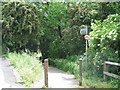
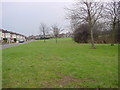
River Eden footpath entrance
Entrance to the River Eden Footpath and Cycle Way accessed from the bottom of Etterby Scaur.
Image: © Andy Connor
Taken: 8 Jun 2008
0.09 miles
9
Grosvenor Court junction with Eden Street
There is an OS benchmark Image on the brick wall above the blue notebook
Image: © Roger Templeman
Taken: 24 Jul 2015
0.09 miles
10
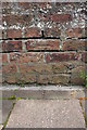
Benchmark on wall of Eden Street
Ordnance Survey cut mark benchmark described on the Bench Mark Database at http://www.bench-marks.org.uk/bm69304
Image: © Roger Templeman
Taken: 24 Jul 2015
0.10 miles