IMAGES TAKEN NEAR TO
Etterby Lea Crescent, CARLISLE, CA3 9JR
Introduction
This page details the photographs taken nearby to Etterby Lea Crescent, CA3 9JR by members of the Geograph project.
The Geograph project started in 2005 with the aim of publishing, organising and preserving representative images for every square kilometre of Great Britain, Ireland and the Isle of Man.

There are currently over 7.5m images from over14,400 individuals and you can help contribute to the project by visiting https://www.geograph.org.uk
Image Map
Images are licensed for reuse under creativecommons.org/licenses/by-sa/2.0
Notes
- Clicking on the map will re-center to the selected point.
- The higher the marker number, the further away the image location is from the centre of the postcode.
Image Listing (47 Images Found)
Images are licensed for reuse under creativecommons.org/licenses/by-sa/2.0
Image
Details
Distance
1
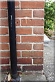
Benchmark on #86 Eden Street
Ordnance Survey cut mark benchmark described on the Bench Mark Database at http://www.bench-marks.org.uk/bm69302
Image: © Roger Templeman
Taken: 24 Jul 2015
0.09 miles
2
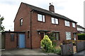
Nos. 86 and 84 Eden Street
There is an OS benchmark Image on the corner, left hand face, of the nearer house, right of the black downpipe
Image: © Roger Templeman
Taken: 24 Jul 2015
0.10 miles
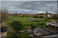
5
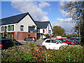
North Carlisle Medical Centre
Opened in April 2014, the Centre houses a medical practice, community health services and a pharmacy.
The land was formerly occupied by Belah School, which closed in 2008 and was demolished about eighteen months later - see photo taken in 2006 Image .
Image: © Rose and Trev Clough
Taken: 14 Oct 2015
0.12 miles
6
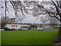
Belah Primary School
Flat roofed post-war construction.
Image: © Bob Jenkins
Taken: 13 Jan 2006
0.12 miles
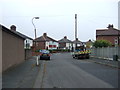
7
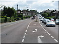
Scotland Road, Carlisle (A7)
Looking south in the direction of Carlisle City Centre.
Image: © G Laird
Taken: 6 Aug 2009
0.12 miles
9
Former "Beerhouse Off-Licence", Eden Street, Carlisle - May 2017
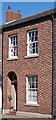
According to State Management Scheme records, this unassuming Georgian terrace house was once the "Beerhouse Off-Licence". It was bought by the State on 3 August 1916 and promptly disappears from available records. It is assumed the off-licence was instantly closed by the Scheme and has been a private dwelling for the last 100 years or so.
Image: © The Carlisle Kid
Taken: 11 May 2017
0.13 miles
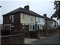
10
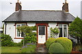
'Hindle Cottage', #88 Scotland Road
The cottage carries 1844 on its name sign. I wonder if this cottage was the National School house mentioned in an Ordnance Survey abstract giving details of benchmarks levelled on the Carlisle to Sark Bridge geodetic line, see http://www.bench-marks.org.uk/ew1gl/1GLA_506.png and http://www.bench-marks.org.uk/bm23148
Image: © Roger Templeman
Taken: 18 Jul 2015
0.14 miles