IMAGES TAKEN NEAR TO
Lansdowne Close, CARLISLE, CA3 9HN
Introduction
This page details the photographs taken nearby to Lansdowne Close, CA3 9HN by members of the Geograph project.
The Geograph project started in 2005 with the aim of publishing, organising and preserving representative images for every square kilometre of Great Britain, Ireland and the Isle of Man.

There are currently over 7.5m images from over14,400 individuals and you can help contribute to the project by visiting https://www.geograph.org.uk
Image Map
Images are licensed for reuse under creativecommons.org/licenses/by-sa/2.0
Notes
- Clicking on the map will re-center to the selected point.
- The higher the marker number, the further away the image location is from the centre of the postcode.
Image Listing (13 Images Found)
Images are licensed for reuse under creativecommons.org/licenses/by-sa/2.0
Image
Details
Distance
2
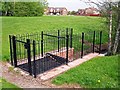
Gosling Sike going into a culvert
A small stream, which is culverted under the road at Windsor Way.
The screen may have been installed to stop debris blocking the culvert, or to prevent children going in, or both https://www.gov.uk/government/publications/trash-and-security-screen-guide-2009 .
Image: © Rose and Trev Clough
Taken: 10 May 2016
0.13 miles
3
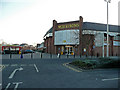
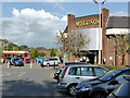
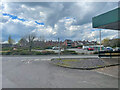
Morrisons supermarket, Kingstown Road, Carlisle
To the east of the A7 heading north out of town.
Image: © Jonathan Billinger
Taken: 13 Feb 2008
0.14 miles
4
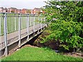
Footbridge across Gosling Sike
This small stream runs through green amenity space between Wolsty Close (seen in distance) and Windsor Way.
Image: © Rose and Trev Clough
Taken: 10 May 2016
0.15 miles
6
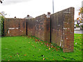
Back of mystery wall, Scotland Road
Front view here Image .
Quite a complex shape and looks well built. We do not know its purpose.
Possibly protecting a culverted beck, Gosling Sike, which flows underground in this vicinity - there is an old bridge parapet on the opposite side of the road Image
Image: © Rose and Trev Clough
Taken: 18 Oct 2017
0.23 miles
7
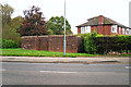
Mystery wall, Scotland Road
It's standing on a patch of grass, not attached to anything. Somebody wrote a letter to the Cumberland News (18.11.2016) asking if anyone knows why it's there, but no replies were printed.
View from the other side here Image .
Image: © Rose and Trev Clough
Taken: 18 Oct 2017
0.24 miles
8
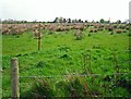
View towards Shortdale Farm from Windsor Way
This view will probably disappear soon, as plans for a large housing development seem likely to go ahead.
Image: © Rose and Trev Clough
Taken: 10 May 2016
0.24 miles
10

Gosling Bridge name stone on SW side of Kingstown Road
The stone indicates that the bridge was widened in 1898 and has Milestone Society National ID: CU_CL07br
Image: © Roger Templeman
Taken: 17 Jan 2022
0.24 miles