IMAGES TAKEN NEAR TO
Larch Drive, CARLISLE, CA3 9FL
Introduction
This page details the photographs taken nearby to Larch Drive, CA3 9FL by members of the Geograph project.
The Geograph project started in 2005 with the aim of publishing, organising and preserving representative images for every square kilometre of Great Britain, Ireland and the Isle of Man.

There are currently over 7.5m images from over14,400 individuals and you can help contribute to the project by visiting https://www.geograph.org.uk
Image Map
Images are licensed for reuse under creativecommons.org/licenses/by-sa/2.0
Notes
- Clicking on the map will re-center to the selected point.
- The higher the marker number, the further away the image location is from the centre of the postcode.
Image Listing (10 Images Found)
Images are licensed for reuse under creativecommons.org/licenses/by-sa/2.0
Image
Details
Distance
1
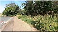
Junction of footpath from bend at NE end of Tarraby Lane
Image: © Roger Templeman
Taken: 30 Jun 2021
0.17 miles
2
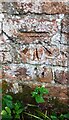
Benchmark on wall on SE side of Tarraby Lane
Ordnance Survey cut mark benchmark levelled at 25.596m above Newlyn Datum verified 1972
Image: © Roger Templeman
Taken: 30 Jun 2021
0.19 miles
3
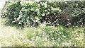
Vegetation beside SE side of Tarraby Lane and brick wall bounding Cumbria University
There is an Ordnance Survey benchmark Image on the buttress on the brick wall
Image: © Roger Templeman
Taken: 30 Jun 2021
0.19 miles
4

Brampton Road, Carlisle
Looking along Brampton Road, a busy road lined with houses.
Image: © Graham Robson
Taken: 6 Oct 2018
0.21 miles
5
![Brampton Road [B6264], Carlisle](https://s0.geograph.org.uk/geophotos/04/73/11/4731124_25feec1a_120x120.jpg)
Brampton Road [B6264], Carlisle
Looking north-east at the junction with Croft Road.
Image: © Christine Johnstone
Taken: 2 Nov 2015
0.22 miles
6

Postbox, Brampton Road, Carlisle
An Edward VII pillar box on Brampton Road in Carlisle.
Image: © Graham Robson
Taken: 6 Oct 2018
0.22 miles
7

Edward VII postbox on Brampton Road, Carlisle
Postbox No. CA3 343.
See Image] for context.
Image: © JThomas
Taken: 20 Nov 2019
0.22 miles
8

Brampton Road (B6264), Carlisle
Showing position of Postbox No. CA3 343.
See Image] for postbox.
Image: © JThomas
Taken: 20 Nov 2019
0.23 miles
9
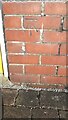
Benchmark on the garage of #42 Brampton Road
Ordnance Survey cut mark benchmark described on the Bench Mark Database at www.bench-marks.org.uk/bm111715
Image: © Roger Templeman
Taken: 4 Jun 2021
0.24 miles
10

#42 Brampton Road
There is an Ordnance Survey cut mark benchmark Image on the right hand front face of the garage (at the left hand edge of the image)
Image: © Roger Templeman
Taken: 16 Sep 2019
0.24 miles