IMAGES TAKEN NEAR TO
Romanby Close, CARLISLE, CA3 9DX
Introduction
This page details the photographs taken nearby to Romanby Close, CA3 9DX by members of the Geograph project.
The Geograph project started in 2005 with the aim of publishing, organising and preserving representative images for every square kilometre of Great Britain, Ireland and the Isle of Man.

There are currently over 7.5m images from over14,400 individuals and you can help contribute to the project by visiting https://www.geograph.org.uk
Image Map
Images are licensed for reuse under creativecommons.org/licenses/by-sa/2.0
Notes
- Clicking on the map will re-center to the selected point.
- The higher the marker number, the further away the image location is from the centre of the postcode.
Image Listing (105 Images Found)
Images are licensed for reuse under creativecommons.org/licenses/by-sa/2.0
Image
Details
Distance
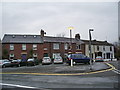
2
Romanby Close
This area was part of the Roman Fort of Petriana, which was built in AD122.
Image: © Mary and Angus Hogg
Taken: 24 Jan 2015
0.03 miles
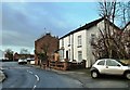
3
Mulcaster Crescent
A residential area on the north side of Carlisle.
Image: © Mary and Angus Hogg
Taken: 5 Jul 2014
0.06 miles
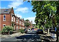
4
The Crown and Thistle, Stanwix
Looking along Church Street towards St. Michael's Church.
Image: © Rose and Trev Clough
Taken: 17 Sep 2009
0.06 miles
5
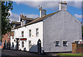
Crown & Thistle, Stanwix - June 2017 (1)
Late 18th or early 19th Century pub which was State Managed from 4 August 1916 until sold to Greenall Whitley on 3 April 1973. Still trading.
Rose & Trev Clough visited on 17 September 2009 - see: Image
See also: Image], Image] and Image
Photograph is for record only - I have no connection with this business and cannot advise on its products or services.
Image: © The Carlisle Kid
Taken: 7 Jun 2017
0.06 miles
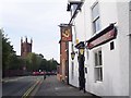
6
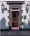
Crown & Thistle, Stanwix - June 2017 (2)
The pub entrance.
For information on this building, see: Image] .
Image: © The Carlisle Kid
Taken: 7 Jun 2017
0.06 miles
7
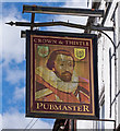
Crown & Thistle, Stanwix - June 2017 (3)
The pub sign - which appears to depict King James I (VI), who unified the Crowns of England and Scotland after the death of Queen Elizabeth.
See also: Image] .
Image: © The Carlisle Kid
Taken: 7 Jun 2017
0.06 miles
8
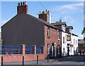
Crown & Thistle, Stanwix - June 2017 (4)
Looking north up Church Street.
For information on the Crown & Thistle, see: Image] .
Image: © The Carlisle Kid
Taken: 7 Jun 2017
0.06 miles
9
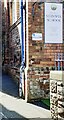
Benchmark on Stanwix School
Ordnance Survey cut mark benchmark in the bricks on the left hand face of the near corner of the school building about half way between ground and the bend in the downpipe, described on the Bench Mark Database at www.bench-marks.org.uk/bm30941
Image: © Roger Templeman
Taken: 15 Apr 2021
0.07 miles
10
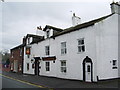
Crown & Thistle, Church Street, Stanwix, Carlisle
Image: © Alexander P Kapp
Taken: 24 Apr 2008
0.07 miles