IMAGES TAKEN NEAR TO
Church Lane, CARLISLE, CA3 9DP
Introduction
This page details the photographs taken nearby to Church Lane, CA3 9DP by members of the Geograph project.
The Geograph project started in 2005 with the aim of publishing, organising and preserving representative images for every square kilometre of Great Britain, Ireland and the Isle of Man.

There are currently over 7.5m images from over14,400 individuals and you can help contribute to the project by visiting https://www.geograph.org.uk
Image Map (Loading...)


Getting Data...Please wait
Leaflet Map data © OpenStreetMap
Images are licensed for reuse under creativecommons.org/licenses/by-sa/2.0
Notes
- Clicking on the map will re-center to the selected point.
- The higher the marker number, the further away the image location is from the centre of the postcode.
Image Listing (118 Images Found)
Images are licensed for reuse under creativecommons.org/licenses/by-sa/2.0
Image
Details
Distance
1

St Michael's Church, Stanwix, Carlisle
Image: © Neil Theasby
Taken: 12 Aug 2017
0.03 miles
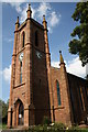
2
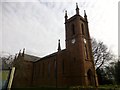
St Michael's Church, Stanwix
The present church was erected in 1841 to accommodate the growing population of the parish. It is a Grade II listed building in sandstone, with some interesting stained glass commemorating the Roman history of the area. There has been a succession of churches on this site for at least 1,000 years, but there is archaeological evidence of Christian worship dating back to the early years of the Roman occupation.
Image: © Rude Health
Taken: 23 Mar 2015
0.04 miles
3
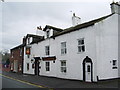
Crown & Thistle, Church Street, Stanwix, Carlisle
Image: © Alexander P Kapp
Taken: 24 Apr 2008
0.04 miles
4
Location of OS Published Abstract Bolt - Carlisle, Stanwix St Michael's Church
Image: © thejackrustles
Taken: 8 Jul 2022
0.04 miles
5
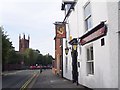
The Crown and Thistle, Stanwix
Looking along Church Street towards St. Michael's Church.
Image: © Rose and Trev Clough
Taken: 17 Sep 2009
0.04 miles
6
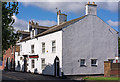
Crown & Thistle, Stanwix - June 2017 (1)
Late 18th or early 19th Century pub which was State Managed from 4 August 1916 until sold to Greenall Whitley on 3 April 1973. Still trading.
Rose & Trev Clough visited on 17 September 2009 - see: Image
See also: Image], Image] and Image
Photograph is for record only - I have no connection with this business and cannot advise on its products or services.
Image: © The Carlisle Kid
Taken: 7 Jun 2017
0.04 miles
7
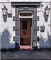
Crown & Thistle, Stanwix - June 2017 (2)
The pub entrance.
For information on this building, see: Image] .
Image: © The Carlisle Kid
Taken: 7 Jun 2017
0.04 miles
8
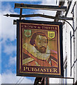
Crown & Thistle, Stanwix - June 2017 (3)
The pub sign - which appears to depict King James I (VI), who unified the Crowns of England and Scotland after the death of Queen Elizabeth.
See also: Image] .
Image: © The Carlisle Kid
Taken: 7 Jun 2017
0.04 miles
9
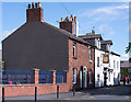
Crown & Thistle, Stanwix - June 2017 (4)
Looking north up Church Street.
For information on the Crown & Thistle, see: Image] .
Image: © The Carlisle Kid
Taken: 7 Jun 2017
0.04 miles
10
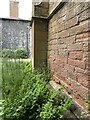
St Michael's Church
The flagstaff on top of the tower is an Ordnance Survey intersected station trig point, http://www.trigpointinguk.com/trigs/trig-details.php?t=10589
There is also an OS 1GL bolt benchmark Image levelled in 1844 on the buttress on the SW angle of the tower and described on the Bench Mark Database at http://www.bench-marks.org.uk/bm19767
Image: © Roger Templeman
Taken: 30 Jul 2011
0.04 miles