IMAGES TAKEN NEAR TO
Rickergate, CARLISLE, CA3 8XP
Introduction
This page details the photographs taken nearby to Rickergate, CA3 8XP by members of the Geograph project.
The Geograph project started in 2005 with the aim of publishing, organising and preserving representative images for every square kilometre of Great Britain, Ireland and the Isle of Man.

There are currently over 7.5m images from over14,400 individuals and you can help contribute to the project by visiting https://www.geograph.org.uk
Image Map
Images are licensed for reuse under creativecommons.org/licenses/by-sa/2.0
Notes
- Clicking on the map will re-center to the selected point.
- The higher the marker number, the further away the image location is from the centre of the postcode.
Image Listing (1040 Images Found)
Images are licensed for reuse under creativecommons.org/licenses/by-sa/2.0
Image
Details
Distance
1

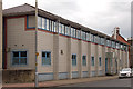
Former "Malt Shovel", Rickergate, Carlisle - June 2017
The original "Malt Shovel" was at least 18th Century and famous for Robert Burns staying there on 31 May 1787 (his state of sobriety at the time is not recorded). Owned by Carlisle City Council, it was sold in 1894 to Workington Brewery for £2,000, these funds going towards establishment of Tullie House library and museum.
Acquired by the State Management Scheme on 24 July 1916, the old pub was pulled-down in 1927 and replaced with these Redfern designed premises, which opened in August 1928. Sold to Greenall Whitley on 3 April 1973, date of closure and conversion to current use has not been traced. The building suffered flood damage in 2015 and has only recently reopened.
Photograph is for record only - I have no connection with this business and cannot advise on their products or services.
Image: © The Carlisle Kid
Taken: 7 Jun 2017
0.00 miles
2
Lost pubs of Rickergate - June 2017 (3)
As mentioned in: Image], all the pubs in Rickergate have been demolished over the years with the exception of the former "Malt Shovel". This modern 21st Century extension to Carlisle Magistrates Court (a prime contender in any "ugly building" competition) certainly sits on the site of the "Blue Bell Inn" and may also occupy part of the "Scotch Arms Hotel". Both were acquired by the State Management Scheme in 1916, with the Scotch Arms closed on 23 October 1916 and the Blue Bell closed in April 1917. For a time, the cleared site was occupied by Carlisle's bus station.
Image: © The Carlisle Kid
Taken: 25 Jun 2017
0.01 miles
3
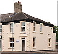
Former "Golden Fleece" - June 2017
The property dates from the building of Corporation Road between 1843 and 1849, with the first reference to a pub coming in 1847, when it may have been known as "The Buck". It seems to have closed circa 1855, but returns as a pub in 1861 when named "Golden Fleece". Owned in the 1890s by Trimble's Dalston brewery, it was leased circa 1911 to Maryport Brewery Co and acquired by the State Management Scheme on 16 October 1916. Closed 1928 on the opening of the Redfern designed Malt Shovel.
Photograph is for record only - I have no connection with any business seen in this view and cannot advise on their products or services.
Image: © The Carlisle Kid
Taken: 14 Jun 2017
0.01 miles
4
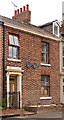
Former "Crown" pub, Corporation Street - June 2017
Probably dating from the building of Corporation Street 1843-49, the "Crown" pub was first licensed about 1855. It was closed by the State Management Scheme on 17 September 1916 and has been a private dwelling for the past 100 years.
Image: © The Carlisle Kid
Taken: 25 Jun 2017
0.02 miles
5
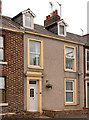
Former "Dukes Head" pub, Corporation Street - June 2017
Just to the right of the former "Crown" pub (see: Image]), the "Dukes Head" also probably dates from 1843-49, although it is first recorded as licensed premises in 1858. It did not survive to the State Management era, closing at an unknown date between 1902 and 1905.
Image: © The Carlisle Kid
Taken: 25 Jun 2017
0.02 miles
6

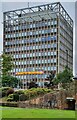
Carlisle's Civic Centre
A functional modern public building in Carlisle city centre.
Image: © Mary and Angus Hogg
Taken: 5 Jul 2014
0.04 miles
9
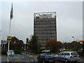
Carlisle Civic Centre
The tall tower of Carlisle Civic Centre seen from the walls of the inner bailey of Carlisle Castle.
Image: © Graham Robson
Taken: 13 Jul 2012
0.04 miles
10
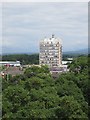
Lost pubs of Rickergate - June 2017 (2)
At the end of the 19th Century, Rickergate boasted at least 14 pubs. However, only 8 survived to the State Management era and 7 of these were closed by the Board between 1916 and 1919. The sole survivor is the former “Malt Shovel Inn” – see: Image] .
Pictured above, Carlisle’s “Civic Centre” is an architectural monstrosity dating from 1964, which has the distinction of being Carlisle's only "tower block". It was built on the site of four State owned pubs, the "Drove Inn”, the "Fox & Hounds", the “Bay Horse” and the “Three Crowns”.
At the far north end of this site opposite Corporation Road, the "Drove Inn" appears to have been a substantial brick-built, two-storey end-terrace property probably built between 1842 and 1844. It was acquired by the State Management Scheme on 23 August 1916 and closed in April 1919. The history of the building between 1919 and 1961 is not known.
Opposite the “Scotch Arms Hotel”, the ”Fox & Hounds” was a narrow, three-storey brick building with a single storey annex to the south. Believed to date from 1722, it closed in 1960 and was pulled-down in 1961. A 1960 view of the "Fox & Hounds" can be seen: http://www.closedpubs.co.uk/cumberland/carlisle_foxhounds.html
The” Bay Horse” was two blocks to the south of the “Fox & Hounds”, between Durham Ox Lane and Bay Horse Lane. Nothing is known of this pub, which was closed by the State on 19 October 1916.
Two blocks south from the “Bay Horse”, the “Three Crowns” was at the junction of Rickergate and Laughran’s Lane. Again, nothing is known of this pub other than its closure by the State on 18 April 1916.
Image: © The Carlisle Kid
Taken: 14 Jun 2017
0.04 miles