IMAGES TAKEN NEAR TO
Hodgsons Court, Scotch Street, CARLISLE, CA3 8PL
Introduction
This page details the photographs taken nearby to Hodgsons Court, Scotch Street, CA3 8PL by members of the Geograph project.
The Geograph project started in 2005 with the aim of publishing, organising and preserving representative images for every square kilometre of Great Britain, Ireland and the Isle of Man.

There are currently over 7.5m images from over14,400 individuals and you can help contribute to the project by visiting https://www.geograph.org.uk
Image Map
Images are licensed for reuse under creativecommons.org/licenses/by-sa/2.0
Notes
- Clicking on the map will re-center to the selected point.
- The higher the marker number, the further away the image location is from the centre of the postcode.
Image Listing (1444 Images Found)
Images are licensed for reuse under creativecommons.org/licenses/by-sa/2.0
Image
Details
Distance
1
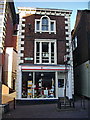
Save the Children, Scotch Street, Carlisle
Image: © Alexander P Kapp
Taken: 23 Apr 2008
0.00 miles
2
Scotch Street (east side) ? The Lanes - February 2018 (3)
Continuing north down Scotch Street, the "Globe Inn" was probably where the "EE" store is now.
For information on "The Lanes", see: Image] .
Photograph is for record only – I have no connection with any business seen in this view and cannot advise on their products or services.
Image: © The Carlisle Kid
Taken: 25 Feb 2018
0.00 miles
3
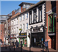
Scotch Street (east side) ? The Lanes - February 2018 (4)
These may be some buildings at the north end of Scotch Street which survived the 1979-80 clearance - if so, the black and white building now "The Fryery" fronted the "Three Cannons Inn", which was closed by the Scheme on 12 July 1916.
For information on "The Lanes", see: Image] .
Photograph is for record only – I have no connection with any business seen in this view and cannot advise on their products or services.
Image: © The Carlisle Kid
Taken: 25 Feb 2018
0.01 miles
4
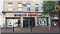
SportsDirect, west side of Scotch Street
Ordnance Survey records describe a benchmark levelled at 20.934m above Newlyn Datum verified in 1972 on a building at the north side of an arch possibly at the entrance doorway to the shop before modification. See www.bench-marks.org.uk/bm74957
Image: © Roger Templeman
Taken: 1 Jun 2021
0.02 miles
5
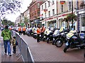
Tour Bikes
The Tour of Britain 2012 police wait in Scotch Street Carlisle for the start of the day's stage.
Image: © Gordon Griffiths
Taken: 12 Sep 2012
0.02 miles
6
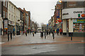
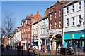
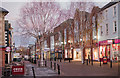
Carlisle, Scotch Street
Looking into the pedestrianised Scotch Street, from West Tower Street.
Image: © David Dixon
Taken: 13 Feb 2013
0.02 miles
7
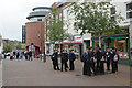
Scotch Street, Carlisle
Groups of schoolboys hang around during their lunch break in the centre of Carlisle.
Image: © Stephen McKay
Taken: 3 Oct 2014
0.02 miles
8
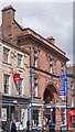
Carlisle Covered Market - Scotch Street entrance - June 2017
Constructed 1888/9 on the site of Captain Cook Lane, the entrance was opened on 2 October 1889 in the presence of Mayor J R Crieighton and some 12,000 people.
Image: © The Carlisle Kid
Taken: 7 Jun 2017
0.02 miles
9
View down Fisher Street, Carlisle - December 2016
Before dawn on a very cold December morning, with nobody stirring!
Photograph is for record only - I have no connection with any business seen in this view and cannot advise on their products or services.
Image: © The Carlisle Kid
Taken: 3 Dec 2016
0.02 miles
10
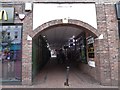
Looking from Scotch Street into Rosemary Lane
Image: © Basher Eyre
Taken: 14 Aug 2017
0.02 miles