IMAGES TAKEN NEAR TO
English Street, CARLISLE, CA3 8ND
Introduction
This page details the photographs taken nearby to English Street, CA3 8ND by members of the Geograph project.
The Geograph project started in 2005 with the aim of publishing, organising and preserving representative images for every square kilometre of Great Britain, Ireland and the Isle of Man.

There are currently over 7.5m images from over14,400 individuals and you can help contribute to the project by visiting https://www.geograph.org.uk
Image Map
Images are licensed for reuse under creativecommons.org/licenses/by-sa/2.0
Notes
- Clicking on the map will re-center to the selected point.
- The higher the marker number, the further away the image location is from the centre of the postcode.
Image Listing (1651 Images Found)
Images are licensed for reuse under creativecommons.org/licenses/by-sa/2.0
Image
Details
Distance
1
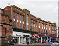
Site of "City Arms" pub - September 2016 (1)
Very difficult to trace now, but this area was the site of Carlisle's most distinctive pub - the "City Arms" (also known as the "Gaol Tap" due to its proximity to Carlisle prison), which was built circa 1858 and decorated in high Victorian style with the City Arms on the pediment and other embellishments!
State managed from July 1916, the site was bought by the Corporation in 1928 and demolished during 1930 - which also lost the Bush Vaults, the Bush Hotel and the Pine Apple Hotel. These buildings - including "Woolworths" in the centre (now occupied by B&M) - date from 1932.
An early 20th Century view of the pub (incorrectly called the Carlisle Arms) can be found: http://closedpubs.co.uk/cumberland/carlisle_carlislearms.html
For another view of this area, see: Image] .
Photograph is for record only - I have no connection with any business seen in this view and cannot advise on their products or services.
Image: © The Carlisle Kid
Taken: 20 Sep 2016
0.00 miles
2
Site of "City Arms" pub - September 2016 (2)
For the story of this area, see: Image] .
Image: © The Carlisle Kid
Taken: 20 Sep 2016
0.00 miles
3
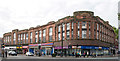
Shops on SW side of road where Carlisle Prison once stood
Image: © Roger Templeman
Taken: 25 May 2023
0.00 miles
4
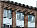
Woolworth Buildings
On English Street. See also Image
Image: © Thomas Nugent
Taken: 22 Apr 2014
0.01 miles
5
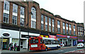
English Street
Including the Woolworth Buildings (now B & M Stores) Image
Image: © Thomas Nugent
Taken: 22 Apr 2014
0.01 miles
6
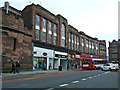
English Street
Looking towards Victoria Viaduct.
Image: © Thomas Nugent
Taken: 22 Apr 2014
0.01 miles
7
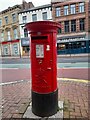
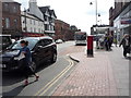
Postbox at Carlisle
CA3 341. Royal Mail list this box as 'English Street D'.
Image: © David Bremner
Taken: 28 Apr 2023
0.01 miles
8
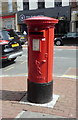
Elizabeth II postbox on English Street, Carlisle
Postbox No. CA3 341.
See Image] for context.
Image: © JThomas
Taken: 28 May 2016
0.01 miles
9
English Street, Carlisle
Showing position of Postbox No. CA3 341.
See Image]for postbox.
Image: © JThomas
Taken: 28 May 2016
0.01 miles
10
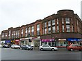
Woolworth Buildings, Carlisle
Taken before we had any idea the Woolworth chain would collapse - this branch closed on 27 December 2008. Woolies had two entrances, here on English Street and around the corner from the bookies on Victoria Viaduct. Woolworth Buildings was opened in 1933, and has its name carved in the centre of the block.
Image: © Rose and Trev Clough
Taken: 6 Sep 2008
0.01 miles