IMAGES TAKEN NEAR TO
Friars Court, CARLISLE, CA3 8LF
Introduction
This page details the photographs taken nearby to Friars Court, CA3 8LF by members of the Geograph project.
The Geograph project started in 2005 with the aim of publishing, organising and preserving representative images for every square kilometre of Great Britain, Ireland and the Isle of Man.

There are currently over 7.5m images from over14,400 individuals and you can help contribute to the project by visiting https://www.geograph.org.uk
Image Map
Images are licensed for reuse under creativecommons.org/licenses/by-sa/2.0
Notes
- Clicking on the map will re-center to the selected point.
- The higher the marker number, the further away the image location is from the centre of the postcode.
Image Listing (1667 Images Found)
Images are licensed for reuse under creativecommons.org/licenses/by-sa/2.0
Image
Details
Distance
1
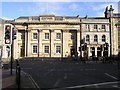
Lloyds TSB, Carlisle
It is located at English Street
Image: © Kenneth Allen
Taken: 8 Oct 2009
0.00 miles
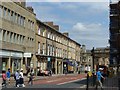
2
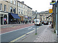
Devonshire Street
Looking towards Lowther Street.
Image: © Thomas Nugent
Taken: 22 Apr 2014
0.01 miles
3
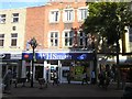
WH Smith, Carlisle
One of these occasions when the light is so contrasty
Image: © Kenneth Allen
Taken: 8 Oct 2009
0.01 miles
4
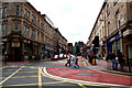
Carlisle: Devonshire Street
Looking west from Lowther Street.
Image: © Dr Neil Clifton
Taken: 6 Jul 2010
0.02 miles
5
Devonshire Street, Carlisle
The terrace of houses on the left hand side (Nos.1-13) date from c.1830 and are Listed Grade II. No.1 retains its original stone shop front with 3 round-topped windows. Listed Grade II.
Image: © Alan Murray-Rust
Taken: 8 Jul 2018
0.02 miles
6
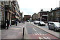
Carlisle: Lowther Street
Looking south from Bank Street and showing the segregated inbound bus lane.
Image: © Dr Neil Clifton
Taken: 6 Jul 2010
0.02 miles
7
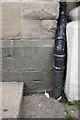
Benchmark on #10 Lowther Street previously Athe?um
Ordnance Survey cut mark benchmark described on the Bench Mark Database at http://www.bench-marks.org.uk/bm38298
Image: © Roger Templeman
Taken: 12 Jun 2011
0.02 miles
8
Former "Friars Tavern", Devonshire Street, Carlisle - June 2017
While the premises are shown on the 1865 OS Map, it is not recorded as a pub - its first mention as licensed premises coming in a survey of 1894. Acquired by the State Management Scheme on 4 September 1916, it was sold to Whitbread in 1973 for £20,100. Now called "The Thin White Duke", it is still trading with the main entrance down the alley at left in this view.
Photograph is for record only - I have no connection with this business and cannot advise on its products or services.
Image: © The Carlisle Kid
Taken: 7 Jun 2017
0.02 miles
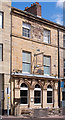
10
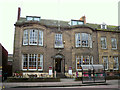
Club 35, Lowther Street (former Liberal Club)
Built in the 1830s as a private house (English Heritage listing http://list.english-heritage.org.uk/resultsingle.aspx?uid=1297408 ), the building was occupied by Carlisle Liberal Club from 1881 until 2008. Club 35 took over the premises shortly afterwards but closed in 2013, a couple of months after this photo was taken.
Image: © Rose and Trev Clough
Taken: 16 Jan 2013
0.02 miles