IMAGES TAKEN NEAR TO
Lowther Street, CARLISLE, CA3 8DP
Introduction
This page details the photographs taken nearby to Lowther Street, CA3 8DP by members of the Geograph project.
The Geograph project started in 2005 with the aim of publishing, organising and preserving representative images for every square kilometre of Great Britain, Ireland and the Isle of Man.

There are currently over 7.5m images from over14,400 individuals and you can help contribute to the project by visiting https://www.geograph.org.uk
Image Map
Images are licensed for reuse under creativecommons.org/licenses/by-sa/2.0
Notes
- Clicking on the map will re-center to the selected point.
- The higher the marker number, the further away the image location is from the centre of the postcode.
Image Listing (1258 Images Found)
Images are licensed for reuse under creativecommons.org/licenses/by-sa/2.0
Image
Details
Distance
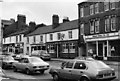
1
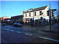
Lowther Street
At the junction with Victoria Place.
Image: © Thomas Nugent
Taken: 3 Jan 2015
0.01 miles
2
Victoria Place
Viewed from Lowther Street.
Image: © Thomas Nugent
Taken: 3 Jan 2015
0.01 miles
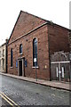
3
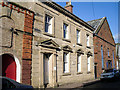
The Dispensary, Chapel Street
Built in 1857, the dispensary provided free medical, surgical and dental treatment for the poor. The dispensary was founded in 1782 by Dr John Heysham, originally at Paternoster Row. It continued its function until the formation of the National Health Service in 1948. Information about the work of the dispensary can be found on the Carlisle History website http://www.carlisleshistory.co.uk/page26.htm .
The building was restored in 1934, the event is recorded on a plaque - see Image .
The site is currently used as a daycare centre.
Image: © Rose and Trev Clough
Taken: 27 Sep 2013
0.02 miles
4

Commemorative plaque on the old Dispensary building
Located between the ground floor windows of Image .
Image: © Rose and Trev Clough
Taken: 27 Sep 2013
0.02 miles
5
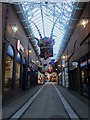
Covered walkway in The Lanes, Carlisle
One of several connected covered walkways which make up the public part of The Lanes shopping centre in Carlisle. In early November 2012 Christmas decorations were making an early appearance with brightly coloured giant presents suspended from the roof.
Image: © Graham Robson
Taken: 4 Nov 2012
0.03 miles
6
Church of Scotland church, Chapel Street
There is an OS benchmark Image on the near corner of the church, on the road face
Image: © Roger Templeman
Taken: 24 Jul 2015
0.03 miles
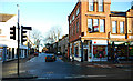
7
Lowther Street
The Howard Arms public house on Lowther Street in Carlisle.
For a view 42 years later, see Image
Image: © Peter McDermott
Taken: Unknown
0.03 miles
8
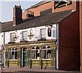
Howard Arms - February 2017 (1)
First recorded in 1854/55 (although the building may date back to 1814), the pub's high Victorian embellishments date from circa 1895, when the pub was under the ownership of Carlisle Old Brewery. All was covered-up when the pub came under State control in August 1916 and not revealed again until 1978 (the State Management Scheme frowned on "advertising").
Sold to John Smiths Brewing Group 7 May 1973, the pub still trades.
See also: Image] , Image] , Image] and Image] .
Photograph is for record only - I have no connection with this business and cannot advise on its products or services.
Image: © The Carlisle Kid
Taken: 14 Feb 2017
0.03 miles
9
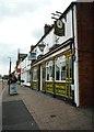
Howard Arms, Carlisle
Public house on Lowther Street, Carlisle.
Image: © Richard Sutcliffe
Taken: 9 May 2019
0.03 miles
10
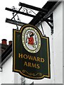
Sign for the Howard Arms
Public house on Lowther Street, Carlisle [https://www.geograph.org.uk/photo/6146539].
Image: © Richard Sutcliffe
Taken: 9 May 2019
0.03 miles