IMAGES TAKEN NEAR TO
Castle Street, CARLISLE, CA3 8AP
Introduction
This page details the photographs taken nearby to Castle Street, CA3 8AP by members of the Geograph project.
The Geograph project started in 2005 with the aim of publishing, organising and preserving representative images for every square kilometre of Great Britain, Ireland and the Isle of Man.

There are currently over 7.5m images from over14,400 individuals and you can help contribute to the project by visiting https://www.geograph.org.uk
Image Map (Loading...)


Getting Data...Please wait
Leaflet Map data © OpenStreetMap
Images are licensed for reuse under creativecommons.org/licenses/by-sa/2.0
Notes
- Clicking on the map will re-center to the selected point.
- The higher the marker number, the further away the image location is from the centre of the postcode.
Image Listing (1497 Images Found)
Images are licensed for reuse under creativecommons.org/licenses/by-sa/2.0
Image
Details
Distance
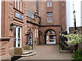
1
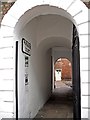
Passageway to Paradise Court
The passage leads to a small courtyard, around which are mid to late 18th century houses now converted to offices.
Its location in Castle Street can be seen on the far left of this photo Image .
The gate is usually shut, but was open for a temporary photographic exhibition being held on the premises.
Image: © Rose and Trev Clough
Taken: 19 Apr 2013
0.01 miles
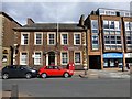
3
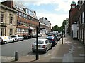
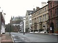
Castle Street, Carlisle
Castle Street leads from Carlisle Castle to the city centre and was at one time the tram route from Carlisle Citadel Station to Newtown, closed by Carlisle Corporation on 21 November 1931.
Castle Street is the route of The Cumbria Way (next photograph Image).
Image: © Adrian Taylor
Taken: 14 May 2014
0.01 miles
4
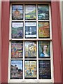
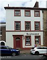
Bookshop window
Works of local interest displayed at Bookcase on Castle Street - for location see http://www.geograph.org.uk/photo/1533189 .
Image: © Rose and Trev Clough
Taken: 25 Dec 2009
0.01 miles
5
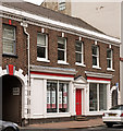
17 Castle Street, Carlisle
Late 18th century house, dated 1798 with the initials J&MF on the rainwater head right. This and its neighbour to the right http://www.geograph.org.uk/photo/5840947 were built by the Foster family which owned a local bank. Listed Grade II.
Image: © Alan Murray-Rust
Taken: 8 Jul 2018
0.01 miles
6
Cat crossing Castle Street
The red sandstone building on the right is part of Tullie House Museum and Art Gallery; Carlisle Cathedral is straight ahead.
Image: © Rose and Trev Clough
Taken: 25 Dec 2009
0.01 miles
7
Former "Bird in Hand" pub, Castle Street - June 2017
The first reference to a "Bird in Hand" pub comes in the 1828/29 Carlisle street directory, although the original building may be earlier. There is uncertainty regarding the exact location of the pub - the only known photograph dates from 1902 and suggests the closed-up doorway evident on the left (beside the archway), together with the ground floor windows may have been the "Bird in Hand" However, the building is much altered from 1902, with the possible loss of a storey and the red door having once been an alley-way.
The pub was closed by the State Management Scheme on 12 July 1916.
Photograph is for record only - I have no connection with any business seen in this view and cannot advise on their products or services.
Image: © The Carlisle Kid
Taken: 25 Jun 2017
0.01 miles
8
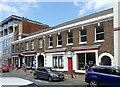
13 & 15 Castle Street, Carlisle
A pair of mid/late 18th century town houses, now converted to retail and office use. Listed Grade II, the listing including a third house (2 Paradise Court) to the rear.
Image: © Alan Murray-Rust
Taken: 8 Jul 2018
0.01 miles
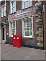
10
Wragg Mark-Bell, Carlisle
They are located at Castle Street
Image: © Kenneth Allen
Taken: 19 Apr 2013
0.02 miles