IMAGES TAKEN NEAR TO
Jaysmith Close, CARLISLE, CA3 0QH
Introduction
This page details the photographs taken nearby to Jaysmith Close, CA3 0QH by members of the Geograph project.
The Geograph project started in 2005 with the aim of publishing, organising and preserving representative images for every square kilometre of Great Britain, Ireland and the Isle of Man.

There are currently over 7.5m images from over14,400 individuals and you can help contribute to the project by visiting https://www.geograph.org.uk
Image Map
Images are licensed for reuse under creativecommons.org/licenses/by-sa/2.0
Notes
- Clicking on the map will re-center to the selected point.
- The higher the marker number, the further away the image location is from the centre of the postcode.
Image Listing (25 Images Found)
Images are licensed for reuse under creativecommons.org/licenses/by-sa/2.0
Image
Details
Distance
1
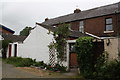
Outbuilding at rear of #95 Kingstown Road
There is an Ordnance Survey cut mark benchmark, http://www.bench-marks.org.uk/bm71600 , on the wall of the outbuilding behind the trellis
Image: © Roger Templeman
Taken: 18 Jul 2015
0.06 miles
2
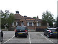
The Gosling Bridge
Public house next to the Premier Inn Carlisle Central North Hotel.
Image: © JThomas
Taken: 3 Oct 2015
0.07 miles
3
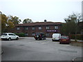
Premier Inn Carlisle Central North Hotel
On Kingstown Road.
Image: © JThomas
Taken: 3 Oct 2015
0.09 miles
5
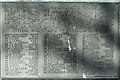
Plaque on war memorial
For the setting, see Image .
Image: © Rose and Trev Clough
Taken: 17 Apr 2011
0.11 miles
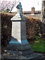
6

War memorial, Stanwix Cemetery
The monument commemorates 'those of this parish' who died in the First World War, which refers to St. Michael's Church, Stanwix (the nearest Anglican church to Stanwix Cemetery today is St. Peter's, Kingmoor, but that was not established until 1931).
For a close look at the inscription, see Image .
Image: © Rose and Trev Clough
Taken: 17 Apr 2011
0.11 miles
7
Memorial to four enginemen, Stanwix Cemetery
The inscription on the front is quite worn. It says "Erected to the memory of four gallant men who lost their lives in the Dinwoodie railway disaster - 25th October 1928 - and were interred in this cemetery".
The two drivers and two firemen died instantly when their double-engine passenger express collided with a broken down freight train. The primary cause was signaller error. A full report of the accident is available on the Railways Archive website http://www.railwaysarchive.co.uk/docsummary.php?docID=2044 .
Dinwoodie is on the West Coast Main Line, between Beattock and Lockerbie http://www.geograph.org.uk/photo/832037 .
Image: © Rose and Trev Clough
Taken: 17 Apr 2011
0.12 miles
8
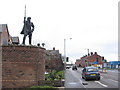
A Border Reiver
A view looking to the southeast along the A7 showing a statue of a Border Reiver, placed by the developer of the property to the left of the image.
Image: © Phil Williams
Taken: 11 Feb 2007
0.12 miles
10
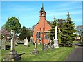
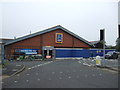
Chapel at Stanwix Cemetery
This municipal cemetery opened in 1887 - the chapel is still in use.
Image: © Rose and Trev Clough
Taken: 17 Apr 2011
0.15 miles