IMAGES TAKEN NEAR TO
Bailey Road, CARLISLE, CA3 0HG
Introduction
This page details the photographs taken nearby to Bailey Road, CA3 0HG by members of the Geograph project.
The Geograph project started in 2005 with the aim of publishing, organising and preserving representative images for every square kilometre of Great Britain, Ireland and the Isle of Man.

There are currently over 7.5m images from over14,400 individuals and you can help contribute to the project by visiting https://www.geograph.org.uk
Image Map
Images are licensed for reuse under creativecommons.org/licenses/by-sa/2.0
Notes
- Clicking on the map will re-center to the selected point.
- The higher the marker number, the further away the image location is from the centre of the postcode.
Image Listing (7 Images Found)
Images are licensed for reuse under creativecommons.org/licenses/by-sa/2.0
Image
Details
Distance
1
#148 Lowry Hill Road, 'Loch-an-Eilein'
Image: © Roger Templeman
Taken: 18 Jul 2015
0.07 miles
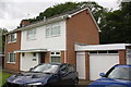
2
No. 148 Lowry Hill Road
There is an Ordnance Survey benchmark Image on the right hand side of the attached garage about 2 feet from its front corner
Image: © Roger Templeman
Taken: 15 Apr 2021
0.08 miles
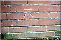
3
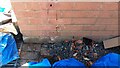
Benchmark on the attached garage of No. 148 Lowry Hill Road
Ordnance Survey cut mark benchmark levelled at 25.805m above Newlyn Datum verified in 1974
Image: © Roger Templeman
Taken: 15 Apr 2021
0.08 miles
5
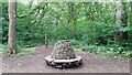
Circular stone seat and wood carving in Kingmoor Nature Reserve
Image: © Luke Shaw
Taken: 17 Aug 2021
0.17 miles
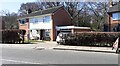
6
Benchmark on the garage of #122 Lowry Hill Road
Ordnance Survey cut mark benchmark described on the Bench Mark Database at http://www.bench-marks.org.uk/bm69290
Image: © Roger Templeman
Taken: 18 Jul 2015
0.19 miles
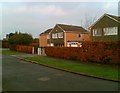
7
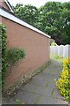
Footpath running past the garage of #122 Lowry Hill
There is an OS benchmark Image on the near end of the garage
Image: © Roger Templeman
Taken: 18 Jul 2015
0.19 miles