IMAGES TAKEN NEAR TO
Netherby Drive, CARLISLE, CA3 0DL
Introduction
This page details the photographs taken nearby to Netherby Drive, CA3 0DL by members of the Geograph project.
The Geograph project started in 2005 with the aim of publishing, organising and preserving representative images for every square kilometre of Great Britain, Ireland and the Isle of Man.

There are currently over 7.5m images from over14,400 individuals and you can help contribute to the project by visiting https://www.geograph.org.uk
Image Map
Images are licensed for reuse under creativecommons.org/licenses/by-sa/2.0
Notes
- Clicking on the map will re-center to the selected point.
- The higher the marker number, the further away the image location is from the centre of the postcode.
Image Listing (30 Images Found)
Images are licensed for reuse under creativecommons.org/licenses/by-sa/2.0
Image
Details
Distance
1
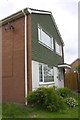
#35 Lowry Hill Road
There is an OS benchmark Image on the blank wall left of the white downpipe
Image: © Roger Templeman
Taken: 18 Jul 2015
0.06 miles
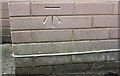
2
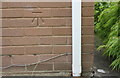
Benchmark on #35 Lowry Hill Road
Ordnance Survey cut mark benchmark described on the Bench Mark Database at http://www.bench-marks.org.uk/bm69292
Image: © Roger Templeman
Taken: 18 Jul 2015
0.06 miles
3
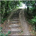
Steps
One of the little hills on the Kingmoor path Network
Image: © David Liddle
Taken: 17 Sep 2014
0.06 miles
4
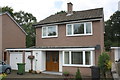
#88 Lowry Hill Road
There is an OS benchmark Image on the right hand side of the house near the front corner
Image: © Roger Templeman
Taken: 18 Jul 2015
0.10 miles
5
Benchmark on #88 Lowry Hill Road
Ordnance Survey cut mark benchmark described on the Bench Mark Database at http://www.bench-marks.org.uk/bm69291
Image: © Roger Templeman
Taken: 18 Jul 2015
0.10 miles
6
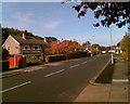
Lowry Hill Road, Lowry Hill, Carlisle
Image: © Adrian Taylor
Taken: 29 Oct 2006
0.10 miles
7
Benchmark on Lowry Hill Road electricity substation
Ordnance Survey cut mark benchmark described on the Bench Mark Database at http://www.bench-marks.org.uk/bm69294
Image: © Roger Templeman
Taken: 18 Jul 2015
0.13 miles
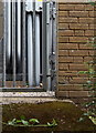
8
Electricity substation on Lowry Hill Road
There is an OS benchmark Image on the building within the compound
Image: © Roger Templeman
Taken: 18 Jul 2015
0.13 miles
9
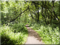
Path in Kingmoor South Nature Reserve
Kingmoor North and Kingmoor South Nature Reserves are the remains of a much larger woodland which extended north from the Kingmoor Road in Carlisle to the M6 Motorway north of the City.
Image: © David Dixon
Taken: 5 Aug 2016
0.13 miles
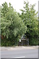
10
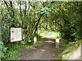
Entrance to Kingmoor Nature Reserve
Kingmoor North and Kingmoor South Nature Reserves are the remains of a much larger woodland which extended north from the Kingmoor Road in Carlisle to the M6 Motorway north of the City.
Image: © David Dixon
Taken: 5 Aug 2016
0.13 miles