IMAGES TAKEN NEAR TO
Lowry Hill Road, CARLISLE, CA3 0DH
Introduction
This page details the photographs taken nearby to Lowry Hill Road, CA3 0DH by members of the Geograph project.
The Geograph project started in 2005 with the aim of publishing, organising and preserving representative images for every square kilometre of Great Britain, Ireland and the Isle of Man.

There are currently over 7.5m images from over14,400 individuals and you can help contribute to the project by visiting https://www.geograph.org.uk
Image Map
Images are licensed for reuse under creativecommons.org/licenses/by-sa/2.0
Notes
- Clicking on the map will re-center to the selected point.
- The higher the marker number, the further away the image location is from the centre of the postcode.
Image Listing (30 Images Found)
Images are licensed for reuse under creativecommons.org/licenses/by-sa/2.0
Image
Details
Distance
1
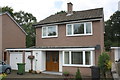
#88 Lowry Hill Road
There is an OS benchmark Image on the right hand side of the house near the front corner
Image: © Roger Templeman
Taken: 18 Jul 2015
0.03 miles
2
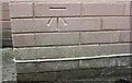
Benchmark on #88 Lowry Hill Road
Ordnance Survey cut mark benchmark described on the Bench Mark Database at http://www.bench-marks.org.uk/bm69291
Image: © Roger Templeman
Taken: 18 Jul 2015
0.03 miles
3
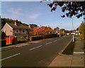
Lowry Hill Road, Lowry Hill, Carlisle
Image: © Adrian Taylor
Taken: 29 Oct 2006
0.04 miles
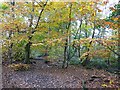
4
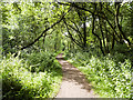
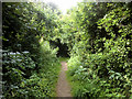
Path in Kingmoor South Nature Reserve
Kingmoor North and Kingmoor South Nature Reserves are the remains of a much larger woodland which extended north from the Kingmoor Road in Carlisle to the M6 Motorway north of the City.
Image: © David Dixon
Taken: 5 Aug 2016
0.06 miles
5
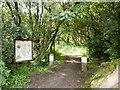
Entrance to Kingmoor Nature Reserve
Kingmoor North and Kingmoor South Nature Reserves are the remains of a much larger woodland which extended north from the Kingmoor Road in Carlisle to the M6 Motorway north of the City.
Image: © David Dixon
Taken: 5 Aug 2016
0.06 miles
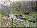
7
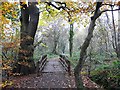
Footbridge, Kingmoor (South) Nature Reserve
Kingmoor is the largest area of woodland in Carlisle, and is managed by the City Council. There are surfaced paths and many benches, making it accessible to people with limited mobility. Once a continuous strip of woodland, Kingmoor Nature Reserve is now segmented by the Kingstown Industrial Estate. See Image
Image: © Rose and Trev Clough
Taken: 5 Nov 2008
0.07 miles
8
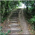
Steps
One of the little hills on the Kingmoor path Network
Image: © David Liddle
Taken: 17 Sep 2014
0.09 miles
9
Bench and pond, Kingmoor (South) Nature Reserve
Image: © Rose and Trev Clough
Taken: 5 Nov 2008
0.10 miles
10
Kingmoor (South) Nature Reserve
King Edward III owned some moorland in this area which he gave to the city of Carlisle in 1352. The "King's Moor" became common land for grazing and peat cutting, and part of it was used as a racecourse. Over the last 300 years woodland has been planted, and also developed naturally. The woodland became a nature reserve in 1914, and today is managed by Carlisle City Council.
Image: © Rose and Trev Clough
Taken: 5 Nov 2008
0.10 miles