IMAGES TAKEN NEAR TO
Newfield Park, CARLISLE, CA3 0AH
Introduction
This page details the photographs taken nearby to Newfield Park, CA3 0AH by members of the Geograph project.
The Geograph project started in 2005 with the aim of publishing, organising and preserving representative images for every square kilometre of Great Britain, Ireland and the Isle of Man.

There are currently over 7.5m images from over14,400 individuals and you can help contribute to the project by visiting https://www.geograph.org.uk
Image Map
Images are licensed for reuse under creativecommons.org/licenses/by-sa/2.0
Notes
- Clicking on the map will re-center to the selected point.
- The higher the marker number, the further away the image location is from the centre of the postcode.
Image Listing (31 Images Found)
Images are licensed for reuse under creativecommons.org/licenses/by-sa/2.0
Image
Details
Distance
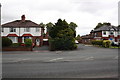
1
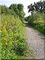
California Lane (behind Newfield Park)
Image: © Rose and Trev Clough
Taken: 18 Aug 2016
0.07 miles
2
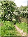
Cut between California Lane and Newfield Drive
Image: © Rose and Trev Clough
Taken: 19 May 2014
0.07 miles
3
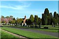
Part of Stanwix Cemetery
The cemetery is run by Carlisle City Council.
Image: © Rose and Trev Clough
Taken: 17 Apr 2011
0.11 miles
4
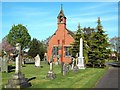
Chapel at Stanwix Cemetery
This municipal cemetery opened in 1887 - the chapel is still in use.
Image: © Rose and Trev Clough
Taken: 17 Apr 2011
0.12 miles
6
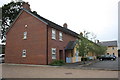
New housing at site of Newfield Grange
Image: © Roger Templeman
Taken: 18 Jul 2015
0.12 miles

8
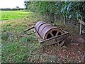
An old field roller
What could be read on the rim : Stalker Bros, engineers, makers, Penrith Cumb.
Stalker Bros. inherited a business established by their father in 1851. They were agricultural engineers, boiler and implement makers, and iron and brass founders. Their foundry was at Castlegate, Penrith - now demolished. The business continued until the late 1960s/early 1970s.
Information from North Pennines Archaeology http://archaeologydataservice.ac.uk/archiveDS/archiveDownload?t=arch-704-1/dissemination/pdf/northpen3-70425_1.pdf .
Image: © Rose and Trev Clough
Taken: 18 Aug 2016
0.12 miles
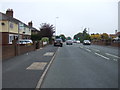
9
Junction of Kingstown Road and Morville Way
Image: © Roger Templeman
Taken: 18 Jul 2015
0.14 miles
10
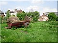
An old farm trailer
In a field to the rear of Image .
Image: © Rose and Trev Clough
Taken: 19 May 2014
0.14 miles