IMAGES TAKEN NEAR TO
Bulwark Quay, WHITEHAVEN, CA28 7HS
Introduction
This page details the photographs taken nearby to Bulwark Quay, CA28 7HS by members of the Geograph project.
The Geograph project started in 2005 with the aim of publishing, organising and preserving representative images for every square kilometre of Great Britain, Ireland and the Isle of Man.

There are currently over 7.5m images from over14,400 individuals and you can help contribute to the project by visiting https://www.geograph.org.uk
Image Map
Images are licensed for reuse under creativecommons.org/licenses/by-sa/2.0
Notes
- Clicking on the map will re-center to the selected point.
- The higher the marker number, the further away the image location is from the centre of the postcode.
Image Listing (348 Images Found)
Images are licensed for reuse under creativecommons.org/licenses/by-sa/2.0
Image
Details
Distance
1
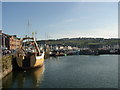
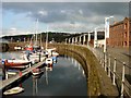
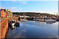
Queen's Dock, Whitehaven Harbour
Looking southwards. In the distance a suburb, much of it council housing, occupies the hilltop.
Image: © Humphrey Bolton
Taken: Unknown
0.03 miles
3
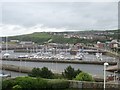
The Marina at Whitehaven
Seen from the hill to the south
Image: © Perry Dark
Taken: 1 Jul 2012
0.03 miles
4
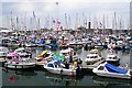
Whitehaven Diamond Jubilee Festival - The Marina
A festival with concerts, displays, markets, funfairs, boats and more took place from 1st to 3rd June 2012 http://www.thefestival.org.uk/ .
Union Jack flags in celebration of Her Majesty's 60 years on the throne were much in evidence.
One small boat (centre front) displayed an unfamiliar flag, of blue and white waves with green above. We later found out this represents the former County of Cumberland, based upon the old coat of arms http://www.abcounties.co.uk/counties/county-flags/county-flag-proposals .
Image: © Rose and Trev Clough
Taken: 2 Jun 2012
0.04 miles
5
Whitehaven Harbour
In the 18th century, Whitehaven was the third largest town in the north of England and was a more important port than Liverpool. Today the harbour is largely used as a marina for pleasure craft.
Image: © Stephen McKay
Taken: 10 Oct 2006
0.04 miles
6
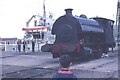
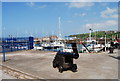
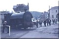
Shunting engine at Whitehaven Docks (Queens Dock)
Image: © Richard Park
Taken: Unknown
0.04 miles
7
Shunting engine at Whitehaven Docks
This photograph looks southeast along Duke Street.
Image: © Richard Park
Taken: Unknown
0.04 miles
10
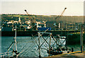
Cranes in the harbour, Whitehaven
I had difficulty working out the subject and camera grid reference. The modern map shows 'travelling Cranes' on Bulwark, and the position of the tower of St Nicholas's church suggests that the camera position was on North Pier, but if so the end of a pier on the right should not be visible. I was evidently using the zoom lens.
Image: © Humphrey Bolton
Taken: Unknown
0.05 miles