IMAGES TAKEN NEAR TO
Toll Bar Crescent, WHITEHAVEN, CA28 6ND
Introduction
This page details the photographs taken nearby to Toll Bar Crescent, CA28 6ND by members of the Geograph project.
The Geograph project started in 2005 with the aim of publishing, organising and preserving representative images for every square kilometre of Great Britain, Ireland and the Isle of Man.

There are currently over 7.5m images from over14,400 individuals and you can help contribute to the project by visiting https://www.geograph.org.uk
Image Map
Images are licensed for reuse under creativecommons.org/licenses/by-sa/2.0
Notes
- Clicking on the map will re-center to the selected point.
- The higher the marker number, the further away the image location is from the centre of the postcode.
Image Listing (21 Images Found)
Images are licensed for reuse under creativecommons.org/licenses/by-sa/2.0
Image
Details
Distance
1
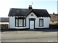
Tollhouse by the A595, Bransty Road, Parton
Tollhouse by the A595, in parish of Parton (Copeland District), Bransty Toll Bar, Bransty Road, CA28 6NE.
Grade II listed.
List Entry Number:1336002 https://historicengland.org.uk/listing/the-list/list-entry/1336002
To be surveyed
Milestone Society National ID: CB.PAR
Image: © Milestone Society
Taken: Unknown
0.02 miles
2
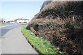
Cutting for A595 at bend at the approach to Parton
Ordnance Survey records indicate a benchmark cut into the rock face here: see www.bench-marks.org.uk/bm112525 for details
Image: © Roger Templeman
Taken: 9 Apr 2018
0.04 miles
3
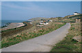
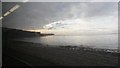
Parton, West Cumbria
View north from Tanyard Bay to Parton and Lowca. The railway is the Barrow - Carlisle line whilst the narrow road was once a tramroad serving Parton Brickworks; it is now a cycleway part of NCN72.
Image: © Ralph Rawlinson
Taken: 2 Apr 2002
0.06 miles
4
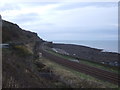
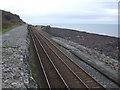
Cumbrian Coast Line near Whitehaven
View from National Cycle Route 72.
Image: © JThomas
Taken: 23 Nov 2019
0.08 miles
9
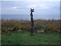
Millennium milepost, National Cycle Route 72 near Parton
Image: © JThomas
Taken: 23 Nov 2019
0.12 miles
10
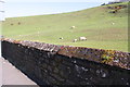
Sheep pasture on east side of A595
Ordnance Survey records show there used to be a gatepost in the wall: see www.bench-marks.org.uk/bm112526 for details
Image: © Roger Templeman
Taken: 9 Apr 2018
0.13 miles