IMAGES TAKEN NEAR TO
Park View, WHITEHAVEN, CA28 6AG
Introduction
This page details the photographs taken nearby to Park View, CA28 6AG by members of the Geograph project.
The Geograph project started in 2005 with the aim of publishing, organising and preserving representative images for every square kilometre of Great Britain, Ireland and the Isle of Man.

There are currently over 7.5m images from over14,400 individuals and you can help contribute to the project by visiting https://www.geograph.org.uk
Image Map
Images are licensed for reuse under creativecommons.org/licenses/by-sa/2.0
Notes
- Clicking on the map will re-center to the selected point.
- The higher the marker number, the further away the image location is from the centre of the postcode.
Image Listing (18 Images Found)
Images are licensed for reuse under creativecommons.org/licenses/by-sa/2.0
Image
Details
Distance
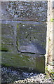
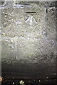
1
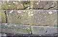
Benchmark on bridge abutment at junction of Park View and Albert Terrace
Ordnance Survey cut mark benchmark levelled at 57.592m above Newlyn Datum. There is more information at www.bench-marks.org.uk/bm103902
Image: © Roger Templeman
Taken: 9 Apr 2018
0.04 miles
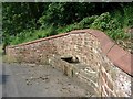
2
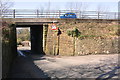
Bridge taking Loop Road North over Park View
There is an OS benchmark Image at the right hand end of the abutment wall
Image: © Roger Templeman
Taken: 9 Apr 2018
0.04 miles
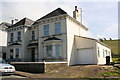
3
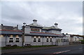
The Sunny Hill public house, Whitehaven
On Victoria Road.
Image: © JThomas
Taken: 16 Nov 2019
0.08 miles
4
A5094 (New Road) heading south through Bransty
Image: © Roger Templeman
Taken: 9 Apr 2018
0.14 miles
5
Benchmark on wall corner at #38 Victoria Road
Ordnance Survey cut mark benchmark levelled at 74.094m above Newlyn Datum
Image: © Roger Templeman
Taken: 9 Apr 2018
0.15 miles
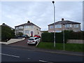
6
Nos. 38 and 40 Victoria Road
There is an OS benchmark Image on the corner of the wall
Image: © Roger Templeman
Taken: 9 Apr 2018
0.15 miles
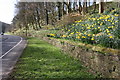
7
Roadside horse trough.
Once a common amenity for the many drayhorses of the town, now a relic of the past. The water supply and drainage are part of the town's extensive well-hidden buried springs and streams.
Image: © Harold Potts
Taken: 10 Jun 2007
0.18 miles
8

Warning Notice, The Green, Bransty.
I was saddened to see this prohibitory notice while visiting this site about 200m from where I was born and grew up. As a lad in the 40's I was frequent witness to an impromptu football game in process here which I think had been going continually since about 1920, Sad that it has been deemed necessary to bring this to an official end.
Image: © Harold Potts
Taken: 10 Jun 2007
0.20 miles
10
Benchmark on the wall of New Road
Ordnance Survey cut mark benchmark described on the Bench Mark Database at http://www.bench-marks.org.uk/bm43735
Image: © Roger Templeman
Taken: 21 Jun 2012
0.21 miles