IMAGES TAKEN NEAR TO
Heysham Gardens, CARLISLE, CA2 7RN
Introduction
This page details the photographs taken nearby to Heysham Gardens, CA2 7RN by members of the Geograph project.
The Geograph project started in 2005 with the aim of publishing, organising and preserving representative images for every square kilometre of Great Britain, Ireland and the Isle of Man.

There are currently over 7.5m images from over14,400 individuals and you can help contribute to the project by visiting https://www.geograph.org.uk
Image Map (Loading...)


Getting Data...Please wait
Leaflet Map data © OpenStreetMap
Images are licensed for reuse under creativecommons.org/licenses/by-sa/2.0
Notes
- Clicking on the map will re-center to the selected point.
- The higher the marker number, the further away the image location is from the centre of the postcode.
Image Listing (40 Images Found)
Images are licensed for reuse under creativecommons.org/licenses/by-sa/2.0
Image
Details
Distance
2
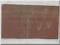
Date stone, St Barnabas Church, Brookside, Carlisle
The date stone embedded in the wall of St Barnabas Church in the Raffles area of Carlisle. The inscription reads:
THIS STONE WAS LAID
ON OCTOBER THE 5TH
1935
Image: © Graham Robson
Taken: 30 Oct 2014
0.08 miles
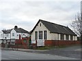
3
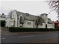
Church of St Barnabas, Brookside, Carlisle
The Parish Church of St Barnabas, located on the junction of Brookside and Shady Grove Road in the Raffles area of Carlisle. The church dates from 1935 Image and is grade II listed ( http://list.english-heritage.org.uk/resultsingle.aspx?uid=1196988 ).
Image: © Graham Robson
Taken: 30 Oct 2014
0.09 miles
4
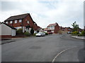
Brookside, Raffles, Carlisle
Looking along Brookside in the Raffles area of Carlisle. The houses lining the street are part of a modern redevelopment which has taken place in the area in recent years in an effort to improve the area.
Image: © Graham Robson
Taken: 30 Oct 2014
0.10 miles
5
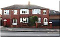
Nos. 261 and 263 Newtown Road
Ordnance Survey records indicate that in 1971 there was a benchmark levelled at 27.581m above Newlyn Datum on the side of the left hand house at its front corner. It appears that a two storey extension has been added on the left hand face of the house (with integral garage on the ground floor) with probable loss of the benchmark described at www.bench-marks.org.uk/bm114679
Image: © Luke Shaw
Taken: 8 Jan 2020
0.10 miles
6
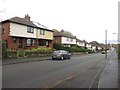
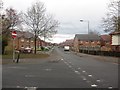
Shady Grove Road, Carlisle
Looking along Shady Grove Road, a long, but quiet residential street lined with semi detached houses.
Image: © Graham Robson
Taken: 30 Oct 2014
0.10 miles
7
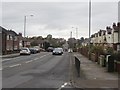
Newtown Road, Carlisle
Looking west along Newtown Road.
Image: © Graham Robson
Taken: 30 Oct 2014
0.11 miles
8
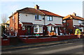
Nos. 53 and 55 Shadygrove Road
There is an OS benchmark Image on the side of the left hand house near its front corner
Image: © Luke Shaw
Taken: 3 Jan 2020
0.12 miles
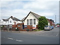
10
St. Barnabas Church Hall, Newtown Road
A stone set into the front of the building says "St. Barnabas Mission Chapel - This stone was laid by Mrs.A.N.Bowman - October 5th 1898". The current St. Barnabas Church (consecrated 1936) is not far away, on Shady Grove Road. On the right of the hall is Caxton Road (full of potholes), which leads to Newtown Industrial Estate.
Image: © Rose and Trev Clough
Taken: 27 Feb 2009
0.12 miles